Dr. David Western, known as Jonah, began research into savannas ecosystems at Amboseli in 1967, looking at the interactions of humans and wildlife.
His work, unbroken since then, has served as a barometer of changes in the savannas and test of conservation solutions based on the continued coexistence of people and wildlife.
Jonah is currently chairman of the African Conservation Centre, Nairobi. He directed Wildlife Conservation Society programs internationally, established Kenya’s Wildlife Planning Unit, chaired the World Conservation Union’s African Elephant and Rhino Specialist Group, and was founding president of The International Ecotourism Society, chairman of the Wildlife Clubs of Kenya, director of Kenya Wildlife Service, and founder of the African Conservation Centre in Nairobi.
He is an adjunct professor in Biology at the University of California, San Diego.
Western’s publications include; Conservation for the Twenty-first Century (OUP, 1989), Natural Connections: Perspectives in Community-based Conservation (Island Press, 1994) and In the Dust of Kilimanjaro (Shearwater, 2001).
He is presently conducting a study on climate change in the Kenya-Tanzania borderlands in collaboration with University of California San Diego, University of York, Missouri Botanical Gardens, and African Conservation Centre.
Dr. David Western
Founder & Chairman
Dr. David Western, known as Jonah, began research into savannas ecosystems at Amboseli in 1967, looking at the interactions of humans and wildlife.
His work, unbroken since then, has served as a barometer of changes in the savannas and test of conservation solutions based on the continued coexistence of people and wildlife.
Jonah is currently chairman of the African Conservation Centre, Nairobi. He directed Wildlife Conservation Society programs internationally, established Kenya’s Wildlife Planning Unit, chaired the World Conservation Union’s African Elephant and Rhino Specialist Group, and was founding president of The International Ecotourism Society, chairman of the Wildlife Clubs of Kenya, director of Kenya Wildlife Service, and founder of the African Conservation Centre in Nairobi.
He is an adjunct professor in Biology at the University of California, San Diego.
Western’s publications include; Conservation for the Twenty-first Century (OUP, 1989), Natural Connections: Perspectives in Community-based Conservation (Island Press, 1994) and In the Dust of Kilimanjaro (Shearwater, 2001).
He is presently conducting a study on climate change in the Kenya-Tanzania borderlands in collaboration with University of California San Diego, University of York, Missouri Botanical Gardens, and African Conservation Centre.
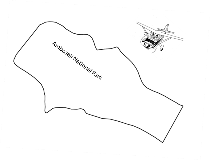
Figure 12:Illustration of how the monthly total count of keystone species is conducted within the Amboseli basin area that includes that protected Amboseli National Park. The counts are done on a one-by-one km grid system.
Dr. Victor N. Mose
Deputy Director & Head of Bio-statistical Services
Amboseli Ecosystem Monitoring
info@amboselimonitoring.org
Nairobi, Kenya
Dr. Victor N. Mose is the Deputy Director and Head of Biostatistical Services. He was awarded a PhD in Biomathematics by the University of Pierre and Marie Curie (UPMC), Paris VI, France in 2013.
He has a Masters in bio-statistics from the University of Nairobi, Kenya and a Bachelors degree in Mathematics from the same University.
He also holds a financial mathematics qualification from the Institute of Actuaries, London, UK.
Victor is experienced in ecological modeling, bio-informatics, and geographical information systems (GIS).
His research interests include Population dynamics, migration modelling, Bayesian spatial analysis, ecosystem services and economics modelling, together with biodiversity mapping.
Victor’s publications include; Mose, V.N., Nguyen-Huu, T., Auger, P., Western, D. 2012. Modelling herbivore population dynamics in the Amboseli National Park, Kenya: Application of spatial aggregation of variables to derive a master model. Ecological Complexity, 10, 42-51.
Dr. Victor N. Mose
Deputy Director & Head of Bio-statistical Services
Dr. Victor N. Mose is the Deputy Director and Head of Biostatistical Services. He was awarded a PhD in Biomathematics by the University of Pierre and Marie Curie (UPMC), Paris VI, France in 2013.
He has a Masters in bio-statistics from the University of Nairobi, Kenya and a Bachelors degree in Mathematics from the same University.
He also holds a financial mathematics qualification from the Institute of Actuaries, London, UK.
Victor is experienced in ecological modeling, bio-informatics, and geographical information systems (GIS).
His research interests include Population dynamics, migration modelling, Bayesian spatial analysis, ecosystem services and economics modelling, together with biodiversity mapping.
Victor’s publications include; Mose, V.N., Nguyen-Huu, T., Auger, P., Western, D. 2012. Modelling herbivore population dynamics in the Amboseli National Park, Kenya: Application of spatial aggregation of variables to derive a master model. Ecological Complexity, 10, 42-51.
Mr. David Maitumo
Field Officer/ Data Collector
Amboseli Ecosystem Monitoring
info@amboselimonitoring.org
Nairobi, Kenya
David has been working in Amboseli as the ACP field officer since 1977. As a member of the local Maasai community in the Amboseli area, David brings a unique perspective to the program.
His rich understanding of the interaction of people, livestock, and wildlife, and the challenges facing conservation in human landscapes, enriches his key roles in the design of field experiments and long term data collection and monitoring.
Mr. David Maitumo
Field Officer/ Data Collector
David has been working in Amboseli as the ACP field officer since 1977. As a member of the local Maasai community in the Amboseli area, David brings a unique perspective to the program.
His rich understanding of the interaction of people, livestock, and wildlife, and the challenges facing conservation in human landscapes, enriches his key roles in the design of field experiments and long term data collection and monitoring.
Ms. Winfridah Kemunto
Database Administrator
Amboseli Ecosystem Monitoring
info@amboselimonitoring.org
Nairobi, Kenya
Winfridah is the Amboseli Conservation Program’s database Administrator. She has a certificate from Pitman Training Institute and vast experience in working with big data that involve database management, basic analysis, digital library, data mining and data visualization.
Her interests include spatial data mining and presentation. Before Joining ACP, she worked as a data clerk at South Rift Land Owners Association (SORALO).
Ms. Winfridah Kemunto
Database Administrator
Winfridah is the Amboseli Conservation Program’s database Administrator. She has a certificate from Pitman Training Institute and vast experience in working with big data that involve database management, basic analysis, digital library, data mining and data visualization.
Her interests include spatial data mining and presentation. Before Joining ACP, she worked as a data clerk at South Rift Land Owners Association (SORALO).
Mr. Sakimba Kimiti
Assistant Researcher
Amboseli Ecosystem Monitoring
info@amboselimonitoring.org
Nairobi, Kenya
Sakimba is currently pursuing a PhD at the University of Lyon 2 in France. He previously worked as an Assistant Researcher for the Amboseli Conservation Program.
He holds a Bachelor of Science (Wildlife Management and Conservation) degree from the University of Nairobi and a Master of Science degree in Range Management from the same University.
Prior to joining the ACP, he worked as an Ecological Assistant at South Rift Land Owners Association. At ACP, he is involved in projects dealing with the Dynamics of Predation on Spatial -temporal Basis and in Human Ecology.
His other interests include: GIS, remote sensing, satellite imagery, ecological monitoring, land use change and ecosystem vulnerability.
Mr. Sakimba Kimiti
Assistant Researcher
Sakimba is currently pursuing a PhD at the University of Lyon 2 in France. He previously worked as an Assistant Researcher for the Amboseli Conservation Program.
He holds a Bachelor of Science (Wildlife Management and Conservation) degree from the University of Nairobi and a Master of Science degree in Range Management from the same University.
Prior to joining the ACP, he worked as an Ecological Assistant at South Rift Land Owners Association. At ACP, he is involved in projects dealing with the Dynamics of Predation on Spatial -temporal Basis and in Human Ecology.
His other interests include: GIS, remote sensing, satellite imagery, ecological monitoring, land use change and ecosystem vulnerability.
Ms. Immaculate Ombongi
Data Analyst
Amboseli Ecosystem Monitoring
info@amboselimonitoring.org
Nairobi, Kenya
Immaculate is a data analyst at ACP. She has a Bachelors’ degree in Financial Economics from Mount Kenya University.
She is experienced in spatial data analysis and modeling of livestock markets in Kenya. Her interests include GIS, remote sensing, satellite imagery processing and analysis.
Immaculate as well, supports the analysis team that is working on the Rangeland restoration, a program of the African Conservation Centre, also known as the JUSTDIGGIT project.
Ms. Immaculate Ombongi
Data Analyst
Immaculate is a data analyst at ACP. She has a Bachelors’ degree in Financial Economics from Mount Kenya University.
She is experienced in spatial data analysis and modeling of livestock markets in Kenya. Her interests include GIS, remote sensing, satellite imagery processing and analysis.
Immaculate as well, supports the analysis team that is working on the Rangeland restoration, a program of the African Conservation Centre, also known as the JUSTDIGGIT project.
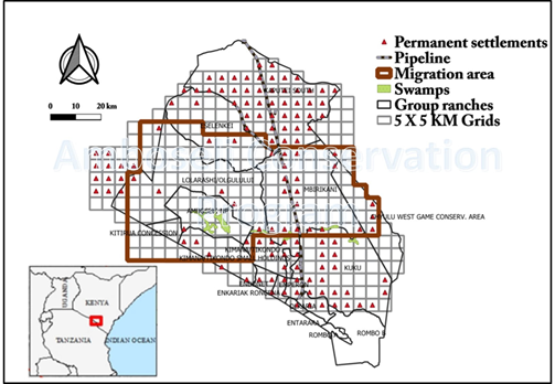
Figure 1: Amboseli National Park is surrounded by Maasai group ranches. ACP has conducted aerial surveys of the 8,500 square kilometers eastern Kajiado region since 1973 using a 5 x 5 kilometer-square grids to count and map wildlife and livestock. The brown box (migration area) defines the Amboseli ecosystem—the seasonal range of the migratory wildlife populations using Amboseli National Park and permanent swamps in the dry season. Ground vegetation monitoring is done at basin area surrounding the Park and in selected group ranches (Olgulului, Kimana, Eselenkei and Mbirikani).
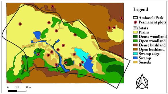
Figure 2: Major habitats amalgamated into eight habitats from 29 vegetation zones defined in the 1967 baseline and subsequent surveys. The 10m radius permanent plots monitored every 4 to 6 weeks are shown. The 20 vegetation plots were selected from a randomized set of 101 original plots. (4)
Lorem ipsum dolor sit amet, consectetur adipiscing elit. Ut elit tellus, luctus nec ullamcorper mattis, pulvinar dapibus leo.
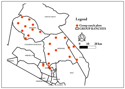
Figure 3: Ground vegetation monitoring in selected group ranches. The plots where monitoring is done within the ranches are also shown.
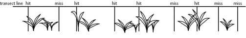
Figure 5: Percentage cover showing number of hits, misses and total number of pins captured. For instance, percentage cover here is calculated as: (Number of Hits)/(Total number of pins) × 100, which gives, 5/9 × 100=55.6. The grass height is recorded in cm.
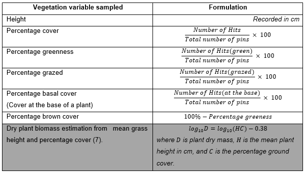
Table 1: Calculations and estimates of vegetation variables collected in the permanent plots in the basin and the surrounding group ranches.
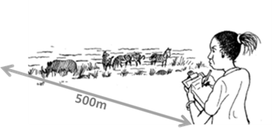
Figure 8: Counting of all herbivore species (including livestock) seen over the 500m radius from the centre of the plots scattered across the Amboseli ecosystem .
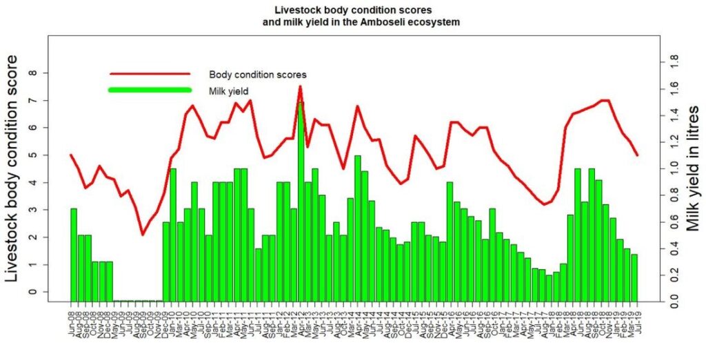
Figure 9 : Livestock body condition scores and milk yield in the Amboseli ecosystem
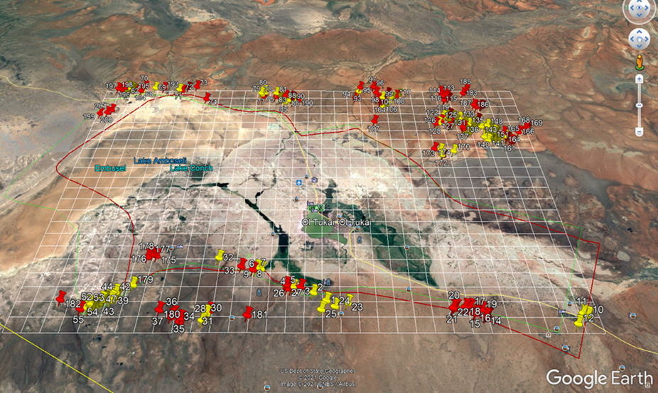
Figure 15: A screenshot of Google Earth showing human settlement locations in the Amboseli basin area. The red placemarks show occupied settlements while the yellow ones represent the unoccupied
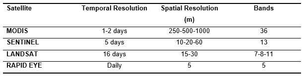
Table 4: Some satellites and their Spatio-temporal resolution
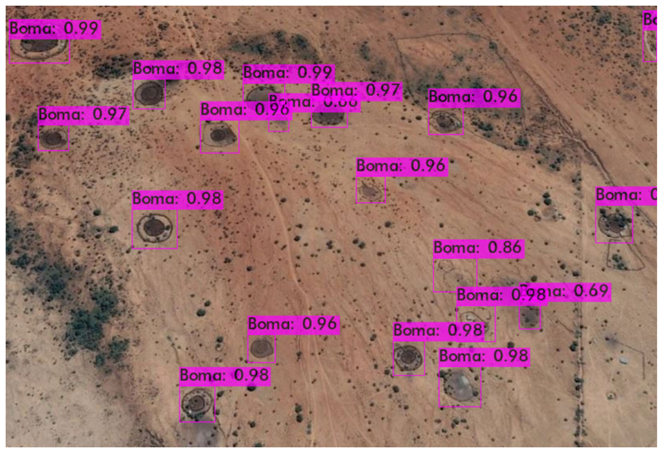
Figure 16: Detected bomas identified by the use of Machine Learning in the Amboseli basin area.
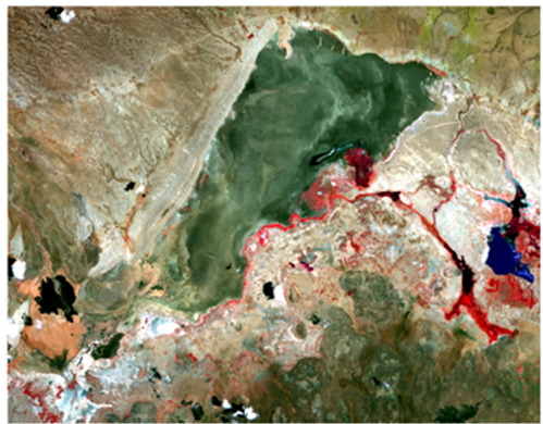
Figure 17: A recent sample of the Sentinel 2 image obtained for processing of the vegetation zones of the Amboseli basin area. The swamp habitat is reasonably distinguished by color red.
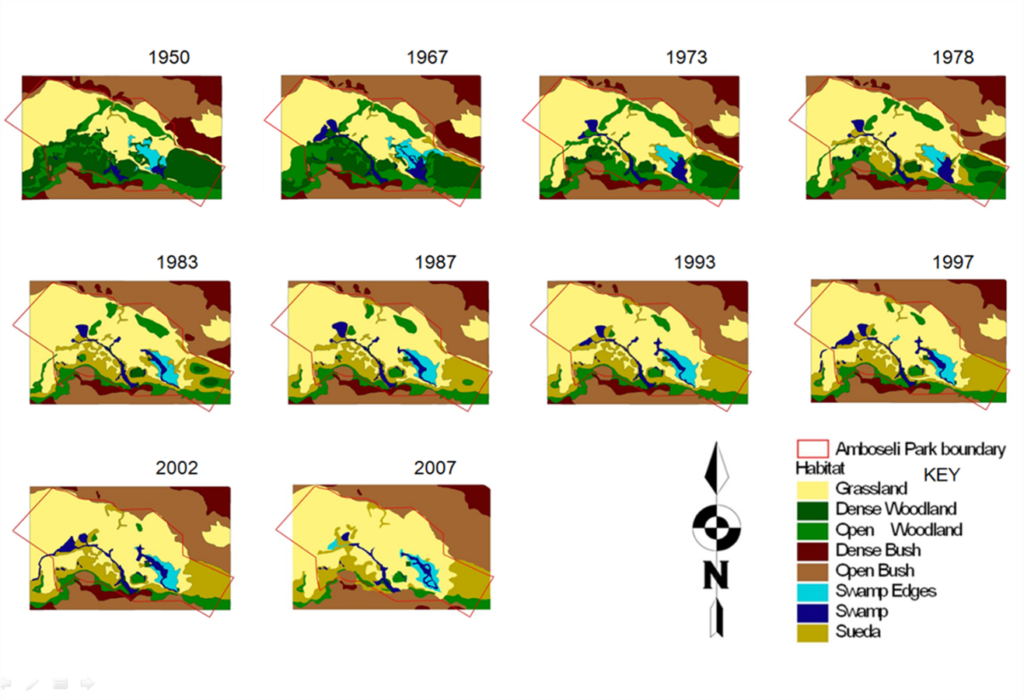
Figure 18: Historical changes in the Amboseli basin vegetation from aerial photography mapping that are currently being updated using satellite imagery.