Ecosystem News
Bucking the dismal decline in wildlife: Amboseli numbers are going up
Bucking the dismal decline in wildlife: Amboseli numbers are going up
Amboseli Conservation Program’s five decades of continuous monitoring the Amboseli region shows an astonishing turnaround for wildlife after years of decline. Many species are now more abundant than forty-five years ago, a remarkable contrast to the rapid losses across Africa and around the world.
What explains this small point of light in a gloomy outlook for wildlife? What lessons does Amboseli offer conservation? And how can the success be kept up as the space for wildlife shrinks?
As scientists patch together wildlife counts of the past few decades, a dismal picture emerges. Joseph Ogutu and associates (2016) show wildlife to have declined by over two thirds in Kenya since the late 1970s. Western and colleagues found similar declines in protected areas (Western et al., 2009), and yet other biologists show numbers to have fallen by well over a half across Africa (Caro and Scholte, 2007; Craigie et al., 2010).
Africa’s wildlife losses mirror worldwide trends. The World Wildlife Fund’s distillation of 14,000 populations of 3,700 species of mammals, birds, fish, amphibians, and reptiles have slumped by nearly sixty percent in forty years (WWF 2016). The causes? Over-harvesting, land and habitat loss, ecosystem degradation and climate change.
In our ACP counts of the eastern Kajiado’s former pastoral lands north and south of Amboseli we find the same picture. Here, where migratory populations of wildebeest, zebra, elephants, giraffe and eland spread from the slopes of Kilimanjaro to the Mombasa Road in the early 1970s, the herds have all but vanished. Amboseli stands alone as the only ecosystem in Kenya to have sustained its wildlife numbers since the 1970s. More remarkably, the numbers of two threatened species, the elephant and giraffe, have grown.
Let’s take a closer look at the Amboseli record and the cause of its conservation success.
The causes of wildlife declines in eastern Kajiado as in Kenya generally include population growth, land pressures, sedentarization, pasture degradation, poaching, human-wildlife conflict, and drought (Western et al. 2009a, Ogutu et al. 2014, Okello et al. 2016). Of the many threats, by far the gravest is subdivision and settlement.
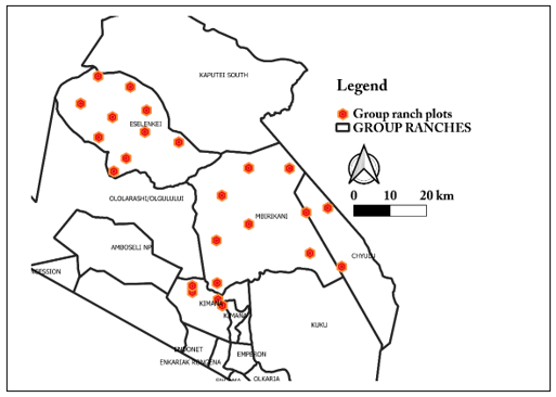
The impact of privatization and burgeoning permanent settlements on wildlife in the formerly open pastoral lands is well documented after the subdivision of the Kaputei Group Ranches north of Amboseli. Here, wildlife declined sharply from 1970 to 2005 following land subdivision (Western et al. 2009a). In stark contrast, wildlife increased on the adjacent open lands of Mbirikani Group Ranch (see figure below). The losses on the privatized Kaputei ranches arose from displacement by closely spaced settlements and pasture losses due to heavy year-round grazing (Groom and Western 2013). Aerial counts we’ve conducted since 2005 show wildlife declining faster still on Kaputei and Mbirikani rebounding strongly after the severe drought of 2009.
The future of Nairobi National Park: a review of the 2022-2030 plan
The future of Nairobi National Park: a review of the 2022-2030 plan
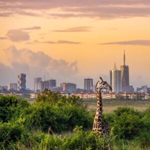 The Kenya Wildlife Service has floated a ten-year plan (2020-2030) for Nairobi National Park. This is timely and urgently needed. Nairobi was Kenya’s first national park, gazetted in 1946. With the park under growing pressure on all sides, and from within, its future looks bleak as the standard bearer of Kenya’s parks.
What better event to celebrate the 75th anniversary of our national park than a plan to secure the future of Nairobi National Park for all time? The ten-year plan to save and restore the park is five years late and doubly urgent because of the delay.
Unfortunately, KWS was put under pressure to ram through the proposal with little public input apart from box-ticking. The railroading ran up against a hail of criticism. Hidden from view were a rash of developments that run counter to the goals of the Wildlife Act 2013: to keep parks in an “untrammeled” natural state.
With KWS already having ceded parts of the park to the Southern Bypass Road, overhead rail line and a goods depot in the works, the public criticisms are well grounded.
I participated in public reviews of the Nairobi National Park 2020-2030 plan and have given my comments at various meetings and to KWS directly. I feel strongly that the plan needs all the public participation it can get and will be greatly strengthened by the input and guidance. Kenya’s parks are, after all, vested in the citizens of Kenya, not the government.
KWS as the custodian has the heavy burden and deep responsibility to ensure its future for all its peoples, and as a world heritage. I was asked by Swara magazine to review the plan. The review is given here. Most of the points are straightforward, but I had too little space to expand on the two most important points of all: fencing and the ecological restoration of the park. I have added some addition points here to clarify my views and recommendations.
I visited NNP regularly in the late 1960s when I was a graduate student at the University of Nairobi starting out on my research and conservation work in Amboseli. The park in the early dry season was like a mini-Serengeti with long lines of zebra and wildebeest snaking back into the park from their wet season migrations on the Athi Plains.
During the rains, large resident herds of kongoni, impala, warthog, gazelle and solitary territorial wildebeest dotted the short grass plains, giving lions and cheetahs abundant prey to keep them in the park. In the early 1970s, as I flew across the Athi Plains to Amboseli, I looked down on the tens of thousands of wildebeest and zebra stretching across the southern plains from Konza to the rift edge during the rains. Traffic on the Namanga Road was often held up for minutes by the migrating herds.
In the early 1980s when I bought land bordering the park, I wandered across the open plains, stretching unbroken to Kajiado, through large herds of eland, wildebeest and zebra, all milling about waiting to file across a narrow defile in the Mbagathi gorge into the park. Within a few years the wildebeest migrations were severed by residential housing.
A solitary male hung on in a resident herd of impala on our land for a further year before he too disappeared. By then the tens of thousands of migratory animals on the Athi Plains had been whittled down by meat poachers, sprawling settlements and fences to a whisper of their former honking masses.
Once the migratory herds dwindled, long grasses and shrubs spang up with the falling grazing pressure and the suspension of burn management programs the wardens formerly used to prevent the invasion of rank vegetation. By the late 1980s, when it was clear that wildebeest were shunning the tall rank grasses in favor of the shorter grasslands on the Athi ranches to the south, I asked Helen Gichohi, a MS student at the time, to conduct an experimental burning program to restore the shorter grasslands.
Her study showed how early burning to create shorter greener grasses became a magnate for wildebeest, zebra, gazelle and warthog, as they were in the 1960s (Gichohi, 1990). We went on to show that the more heavily grazed grasses outside the park were richer and more palatable than the rank grasslands inside. In other words, parks can lose their richness of wildlife and vegetation without restorative management (Western and Gichohi, 1994).
In the mid-1990s, as director of the Kenya Wildlife Service, I used the evidence of Helen’s work to begin restoring the dwindling wildlife numbers and grasslands using an experimental early burning program. The results were dramatic. For the next three years the burned area in the south west of the park drew in large herds of wildlife and an entourage of visitors.
After I left KWS, conservation lobbyists pressured KWS to abandon the restoration program, arguing nature should be left unmanaged. The heavy El Niño rains of 1998 hastened the growth of tall vegetation and the decline of wildlife, especially the smaller species, including gazelles and warthogs.
The dwindling herds of wildebeest and zebra returned to the park later each season and, the once resident herds in the rain season shrank too, lions and cheetahs began regularly attacking livestock outside the park.
By 2010 dense settlements spreading out from Ongata Rongai township and Tuala blocked all wildlife movements at the western end of the park. I saw the last cheetah shortly afterwards and worried about the mounting toll of lion and hyena attacks on livestock and dogs in the residential estates.
The community, angry and scared, demanded KWS remove the predators and fence the park after a series night encounters. In December, the anger bubbled over when a person returning from Tuala late at night was eaten by a lion.
I’m no fan of fencing parks. I’ve done all I can to prevent that happening by promoting community-based conservation and nature enterprises as a win for park neighbors and wildlife. The 150-plus conservancies in Kenya testify to the success—where land is still open. Where parks are surrounded by a sea of settlement, the Aberdare, Shimba and Nakuru among them, fences are vital for protecting wildlife and people.
I’ve promoted fencing in each of these cases and raised funds to electrify the fence hard up against the city on its northern and western boundaries. Yet I hold out the hope of avoiding fencing the park on its southern border.
How in any event would the park be fenced when the center of the Mbagathi River is the park boundary? The only option is to fence inside the river edge, but this would exclude the river, the park’s most important lifeline. There are other problems with fencing in the southern park.
Unless the grasslands and wildlife are restored first, the park will become more of an ecological trap than conservation lifeline as predators drive down the depleted herds even further. The herbivores need as much space and movement as possible to sustain the interplay of predators, prey and healthy pastures.
Adding to the fencing problem, not all residents south of the park agree on the solutions. The Ongata Rongai and Tuala residents want the park fenced now, and there is no other option. The eastern end of the park remains open though, and the largely Maasai ranching community has joined a leasing program to keep wildlife on their lands, hoping to benefit from nature enterprises. Many oppose fencing altogether.
I’ve long advocated that the debate about whether to fence or not should be informed by what is to be fenced in and left out. Even if the park is to be fenced in, the abundance and diversity of plants and animals should be restored first to avoid further ecological decline. KWS is to be commended for making ecological restoration a primary plant of the 2020-2030 Plan.
The restoration program stands to boost wildlife numbers, keep predators anchored in the park, improve habitat quality and diversity, and raise the park’s profile and visitor appeal. I’ve suggested in the Swara article that the southern fence be considered in three phases, emulating the step-by-step approach to fencing in the Aberdare National Park.
For Phase 1, I’ve joined neighboring landowners along the Mbagathi River discussing with KWS a fence running along the back of our properties as far as Maasai Gate. This will give wildlife access to the river and use of our land and prevent predators from straying into the built-up Ongata Rongai and Tuala areas.
Phase 2, running from Maasai Gate to the overhead rail line, needs similar consultations to see how far into the Athi Plains the fence can extend.
Phase 3, from the rail line to the eastern border of the park, is far more contentions. Here most landowners are Maasai ranchers who have formed a wildlife conservancy and land leasing arrangements, hoping to benefit from wildlife on their land.
The prospects for winning a large area of open space for wildlife are good yet call for detailed property and land surveys and open discussions. This will take time. Rushing ahead without due process will anger the community, frustrate KWS and short-change wildlife.
KWS should focus on getting agreement on the broad principles and strategies in the 2020-2030 plan for Nairobi National Park and work out the details as a part of its execution. As the plan stands, it is too saturated with details.
It loses sight of the broad areas of agreement, public support and continuing engagement and refinement needed for the plan to succeed. No two issues in the plan need these open-minded flexible approaches more than ecological restoration and fencing.
Gichohi, H. W. (1990). The Effects of Fire and Grazing on the Grasslands of Nairobi National Park. MSc thesis. University of Nairobi, Nairobi, Kenya.
Western, D. and Gichohi, H. (1994). Segregation effects and the impoverishment of savanna parks: the case for an ecosystem viability analysis. African Journal of Ecology 31 (4): 269-281.
Saving wildlife in a time of coronavirus : the greatest risk to human health around the world since the Spanish flu of 1918
Saving wildlife in a time of coronavirus : the greatest risk to human health around the world since the Spanish flu of 1918
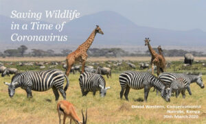 The pandemic is already disrupting every sector of society, from entertainment and sports to manufacturing and the health and service industries.
And the worst is yet to come. Conservationists blame the pandemic on the loss of biodiversity degraded ecosystems and climate change.
They have a point. New virulent diseases, along with invasive species and pests, thrive when nature dies. In the case of the Coronavirus the blame lies squarely on the illegal trade in wildlife species, fueled by globalization.
Diseases such as Ebola, Marburg and HIV erupted in small scattered communities in the past but remained localized epidemics. No longer.
In the last few decades, global travel has spawned virulent novel viruses such as SARS, MERS, H1N1 and COVID-19, infecting hundreds of millions around the world in weeks. These new pandemics are a grave threat to every nation, every individual. causing 6 of 10 infectious diseases, 2.5 billion illnesses and 2.7 million deaths each year.
 The wildlife trade, worth $23 billion annually, operates largely underground like drug trafficking. And like the ivory wars which slashed elephant numbers across Africa from 1.2 million in 1970 to 450,000 today, the wildlife trade is driven by rising wealth in Asia.
Hundreds of species of amphibians, snakes, fish, birds and mammals are butchered for the wildlife trade, among them bats, civets and pangolins suspected of transmitting lethal viruses.
We can’t be sure which species in the wildlife market in Wuhan sparked the COVID-19 pandemic. Regardless, the cramped confined conditions flouting concerns for animal welfare and human health, have unleashed the most devastating pandemic in modern times.
The COVID-19 pandemic has been dubbed the revenge of wildlife. Revenge it isn’t. Coronavirus smites indiscriminately. For every illegal trader infected, hundreds of millions of people are at risk, among them ardent animal lovers, doctors and nurses. Overlooked is the impact of the pandemic on wildlife.
Here’s why, and what you can do about it
 The unseen victims of the tourism collapse are the very communities which protect and benefit from wildlife.
Amboseli, which pioneered community-based conservation in the 1970s, speaks to its success
 Even the giraffe, newly listed as a threatened species, has increased in the last two decades and is among the largest and safest population in Africa. The remarkable success of Amboseli depends on the hundreds of community rangers protecting wildlife, and on the income from tourism which generates jobs, scholarships for children and supports social services and women’s enterprises. Visit here to learn more.
 The South Rift Association of Landowners joining Amboseli to Maasai Mara has shown similar success. The migratory herds and lion numbers have increased, and elephants have returned to the area for the first time in decades.
Amboseli Ecosystem Count February 2020
Amboseli Ecosystem Count February 2020
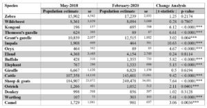 ACP commissioned the Department of Resource Surveys and Remote Sensing (DRSRS) to conduct an aerial count of the Amboseli ecosystem and surrounding areas in February. The sample count covered approximately 7800 km² of Eastern Kajiado between February 10th and February 14th, 2020.
The methodology followed the same procedures and covered the same areas as counts conducted regularly by ACP since 1974.
The results of the February count are given in the table below, followed by the distribution maps for each species.
The counts and standard errors for each species are given in the table alongside figures for the 2018 count to compare changes in population size.
 We draw several conclusions and observations from a comparison of the 2018 and 2020 counts.
There have been significant increases in cattle, sheep and goats, despite the declining trends until 2018 and a sharp fall in body condition and milk yields in cattle over the past two years, as indicated by our pressure gauge index.
The indications are that the higher numbers reflect livestock returning to the Amboseli ecosystem following widespread movements in search of forage during May of 2018 when the count was conducted. A similar case can be made for elephant numbers. During the dry spell of 2018, many elephants moved out of the Amboseli region in search of forage.
Increases in kongoni and warthog numbers may reflect the increased likelihood of being detected during wet rather than dry seasons. The increase in buffalo numbers may reflect the statistical quirk of hitting or missing small clustered herds in the Amboseli basin where monthly total counts record a population of 400 or so.
The increase in Grants gazelle likely continues the upward trend in population over the past decade. The population sizes of Thomson’s gazelle, impala, oryx, ostrich and camel are small, the standard errors large, and so the reliability of detecting actual changes over a two-year very low. ACP is currently completing a detailed analysis of the long-term trends of all species in the ecosystem to amplify the changes and causes.
Perhaps the most reassuring figures in the 2020 count are for zebra, wildebeest, eland and giraffe, the most abundance of the wildlife species. The zebra population is evidently continuing its upward trend since the severe drought of 2009 and is close to the highest peak recorded since 1974.
Wildebeest, eland and giraffe populations all held stable over the past two years despite the declining pasture conditions in 2019. The giraffe result is especially gratifying. At over 6,500, the Amboseli giraffe population is among the largest in Africa and defies the rapid declines recorded across its range in the past few decades.
The long rains in April and May of 2018 were exceptionally heavy and replenished pastures across the region. However, the heavy stocking rates quickly depleted the recovery and set in motion another decline in pasture production throughout 2019 when young livestock began to die.
The torrential short rains which began in September 2019 and continued through to March 2020 have changed what was shaping up to be a severe year. The prolonged rains have pushed pasture production to a peak reached in the El Niño year of 1998. The replenished pastures provided a temporary stay on the steady decline in pasture production recorded since 2016 and will likely see a stepped recruitment in livestock and wildlife populations in the coming year.
Unless, however, there is a reduction in the heavy persistent grazing pressure caused by the current large livestock populations, the pasture restoration seen in increased ground cover and forage production will revert to a downward trend by the end of 2020.
Livestock and their management are key to the future of Africa’s wildlife
Livestock and their management are key to the future of Africa’s wildlife
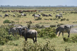 Protected areas have committed over 15 percent of Earth’s lands to the conservation of wildlife. But these are too small and isolated to protect most biodiversity or curtail species losses. In recent decades recognition of these limitations has spurred new ways to buffer parks and safeguard biodiversity by conserving wildlife in human-dominated landscapes.
Moving beyond protected areas calls for realigning conservation paradigms to ensure the lives of rural people are improved and their lands conserved.
In our Review & Synthesis article published in People and Nature, we use a case study from the rangelands of Southern Kenya, to explore how large migratory herds of wildlife which have coexisted with pastoralists for millennia can be sustained by fusing traditional husbandry practices with contemporary governance institutions and conservation policies.
We show how herding families, using the traditional notion of erematare which links the welfare of the family to the productivity of the herd sustained by free-ranging movements across large open landscapes, indirectly conserve wildlife. The value of wildlife as second cattle during droughts is captured by the Maasai saying: “we protected wildlife from hunters, and wildlife protected us from drought. Coexistence is the essence of survival for us both.”
The erematare linkages between the family, their herds, and their mobility in response to forage availability, disease and other hazards, maximize livestock productivity, minimizes drought exposure and facilitates the coexistence with wildlife. The large open landscapes which underlie the success of pastoral economies are intimately linked to an extensive network of associates and governance procedures among herders based on social reciprocity.
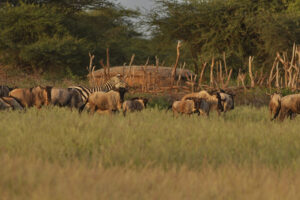 The large open landscapes sustaining pastoral herds and wildlife and their coexistence are facing increases threats across the savannas from land subdivision, sedentarization of herders, and rangeland degradation. We show that the traditional social and ecological linkages embodied in erematare incorporated into contemporary institutions and collective governance procedures can sustain large open landscapes and, in the process, conserve wildlife, pasture, water and natural habitats.
We show that an emerging blend of traditional and contemporary governance institutions can improve family income through livestock and range management and wildlife enterprises. The creation of landowners’ associations focusing on livestock and linked across the landscape to secure mobility, in the face of subdivision and alienation, indirectly conserve regional biodiversity, and the large free-ranging herbivore and carnivore populations support the economy of the region.
The large open landscapes and conservation of habitats also sustains ecosystem functions and services. The “inside-out” approach we highlight reverses the top-down outside interventionist approaches that have typified wildlife protection.
Based on self-interest in improving livelihoods, securing access to large open landscapes and diversifying incomes through wildlife enterprises and natural capital, the inside-out approach has the potential to buffer protected areas and open up large additional landscapes for wildlife in the rangelands, indigenous forest management, and marine fisheries.
Extreme flooding in Amboseli National Park
Extreme flooding in Amboseli National Park
 Background to the floods
The heavy rains in Kenya which began in September and continued through January caused extreme flooding in Amboseli National Park.
By December the floods stretched from the Loitokitok to Namanga roads (see photos below) causing a closure of the airfield and viewing roads. Inbound air traffic was diverted to Tawi and Ol Doinyo Uas strips, resulting in transfer times to the lodges of up to three hours.
The disruptions and tourist complaints carried in the social media led to cancellations and heavy revenue losses to the hotels and the Kenya Wildlife Service (KWS).
The lodges, led by Ol Tukai, called for a meeting in Amboseli on 18th January to see what could be done to open the airstrip, roads and solve the flooding problem. The meeting was chaired by the senior warden of Amboseli, Kenneth Nashu, and attended by KWS road engineers, Ol Tukai Serena and Ol Tukai lodge representatives, Amboseli Trust for Elephants and the Amboseli Conservation Program.
The warden noted that the flooding had grown worse in recent years, was causing extensive damage to the roads and threatened the future of tourism in the park. He asked the meeting to identify the source and cause of the flooding, restorative measures for the airfield and roads, and preventive measures to curb future floods. The lodge operators, raising their concerns about the disruptions to visitors and sharp drop in revenues, asked for emergency measures to restore the park.
 Asked to give a background to the flooding, I made the following points and recommendations which I have supplemented with photos:
- Until 1992 the basin didn’t flood as it now does. The extensive woodlands and shrub cover arrested and contained the heaviest rainfall in small isolated pans.
- The loss of vegetation cover, coupled with extensive erosion from the higher elevations north and south of the basin, has caused the excessive inflow of water channeled into Longinye Swamp and out the far end across the central basin.
- The erosion is due to the permanent settlement and heavy erosion around Amboseli. The extensive flooding began in 1992 after migratory livestock herders set up permanent homes. The heavy permanent grazing caused a loss of ground cover and heavy erosional runoff flooding into the basin. The erosion channels caused by the incoming floods rushing into Longinye Swamp during the rains can be seen in the photo below
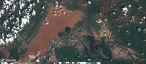 The clearest evidence of the flood waters originating off the heavily eroded lands around the park is captured in the satellite image below taken at the height of the floods.
The flood waters are red-brown, the color of soils surrounding basin, rather than white soils of the basin and the flood pans filled by internal rainfall.
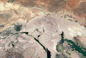 Two troughs stretching across the basin and visible from satellite imagery (below) drained Longinye Swamps into Lake Amboseli during historical periods of high rainfall. These channels have silted up over the decades.
- The drainage troughs can be desilted to carry excess future flooding into Lake Amboseli. The survey and works should be completed before the next rains to avoid another tourist closure.
- In the meantime, I landed at the airstrip before the meeting to show it is fully usable and accessible to four-wheel-drive traffic. The airstrip should be reopened immediately to avoid further tourist disruptions.
- As a short-term measure can be taken to dump and level marram on the five kilometers or so of the main airstrip access and viewing roads. The roads, deflated by years of grading without recapping with marram to keep them raised above surface level, have become ribbon channels in many places.
- In the longer term, a range-land restoration program to combat erosion and restore pasture on the surrounding Ololorashi-Ogulului Group Ranch is underway. The program, funded by the Dutch NGO, Justdiggit through the Amboseli Ecosystem Trust and the African Conservation Centre, should reduce the erosional runoff into the basin in due course.
- One proviso of flood abatement that may need to be considered is whether to retain the enough seasonal flood waters to maintain the great attraction the thousands of flamingoes and water birds have become to the park.
 The way forward
- The meeting agreed that KWS would move ahead immediately to open the airstrip and repair the access roads and main viewing circuits in the central park.
- The lodge representative agreed to provide stop-gap funding if needed.
- KWS, working in collaboration with the lodges and ACP, will conduct a topographic survey to determine the desilting levels needed to channel the Longinye Swamp excess flooding into Lake Amboseli.
- The meeting was a positive step in engaging the tourism industry and conservation organizations in KWS’s planning and management of the park. The meeting should meet again within a month to review progress and become a permanent joint committee working for the future of Amboseli National Park and the larger ecosystem.
An analysis of livestock price fluctuations with droughts in eastern Kajiado
An analysis of livestock price fluctuations with droughts in eastern Kajiado
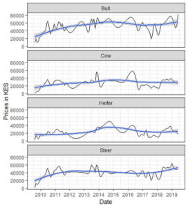 The livestock market in eastern Kajiado has steadily recovered after the near collapse in 2009 owing to the debilitating drought that led to losses of cattle, sheep, goats and donkeys.
Prices fell below 1,000 Kenya shillings for a bull too weak to walk and surged to 90,000 Kenya shillings with the drought breaks (Figure 1). Amboseli Conservation Program monitors livestock market prices on a monthly basis and is in the process of modelling economic losses due to droughts and the gains when herders sell off their livestock early enough before periods of extreme forage shortfall.
 A calibration of livestock prices based on monthly data collected in the ecosystem from 2009 to 2019 shows that the average prices for bulls in 2009 were in the red (Figure 2) falling 80.1 percent below the maximum expected market price.
The market recovered steadily up to 2014 with arrival of widespread rainfall and oscillated with seasonality thereafter.
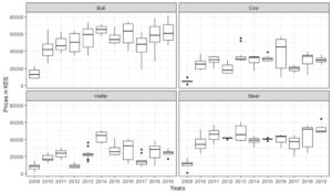 The early warning model can guide herders on when to sell off their livestock based on forage conditions and market forces, while estimating economic losses due to extreme drought.
The subdivision of Ogulului Group Ranch: Does it spell doom for Amboseli’s wildlife?
The subdivision of Ogulului Group Ranch: Does it spell doom for Amboseli’s wildlife?
Ololorashi-Ogulului Group Ranch (OOGR), which surrounds Amboseli National Park, supports most of its migratory wildlife in the wet season. The ranch has recently begun subdividing the 330,000-acre ranch among its 5,000 members.
Conservationists are deeply concerned, fearing there is no place for wildlife on small subdivided lands, and with good reason: ten years ago, Rosemary Groom and I called attention to the steep decline in wildlife following the subdivision and degradation of the Kaputei group ranches north of Amboseli [1].
Today the once large seasonal migrations of wildebeest and zebra have vanished. Wildlife in Amboseli faces a similar fate if OOGR ranch carves up and settles the migratory routes across the ecosystem.
Parks are no panacea for conserving wildlife; numbers are declining in lockstep with losses in the surrounding lands and across Kenya as a whole [2].
How real is the threat of OOGR to the future of Amboseli’s wildlife and the national park?
The subdivision of the Amboseli ecosystem into Kaputei-like settlements reflects a far large threat to Kenya’s rangelands. The Ministry of Lands in 2019 declared that all community lands are open to adjudication into private allotments, opening the floodgates to the fragmentation and degradation of Kenya’s savannas and pastoral livelihoods.
The push for the subdivision of OOGR has been building for two decades. The pressure stems partly from a fear of land grabs, partly from the economic and social transition from subsistence pastoralism to settled livelihoods. The push has been held back by the group ranch and political leaders cautioning members about the dangers of carving up the open rangelands into plots too small to support a family, and the dangers of outsiders and land speculators buying up the pastoral lands.
The leaders point to the fate of Kimana Group Ranch adjacent to Amboseli as a warning. Following subdivision, most of the land was sold to settlers and farmers.
I recently visited the American prairies, which were carved up into similar small parcels in the 1920s, to gauge the risks of subdividing Kenya rangelands. (See A visit to the American Dust Bowl 80 years on: Lessons for the African Savannas). The visit convinced me that family herders and farmers in the African savannas face a similar fate unless the allocation of title deeds takes account of the health of the land.
To avoid Amboseli and Kenya’s rangelands going the Kaputei and Dust Bowl way, OOGR must ensure its members can secure title to their lands without destroying them for livestock and wildlife alike. In short, OOGR is a testcase for future of Kenya’s pastoral lands.
Caught between the pressures for subdivision and concerns over land degradation and sales to outsiders, OOGR has held lengthy discussions over the years to find a balance between land security, settlement, viable family herds and wildlife conservation. A draft plan was presented to wildlife conservation organizations in 2014, soliciting inputs. The final plan, a 100-page document prepared by consultants, was completed early in 2019, approved by Kajiado County and released at a workshop which included the Kenya Wildlife Service and conservation organizations.
In summary, the 330,000 acre OOGR group ranch is being subdivided among its members into four zones: 1) ten village service areas where each member is allocated a quarter acre for settlement and provided social services; 2) a pastoral grazing areas where each member is allocated 21 acres; 3) four wildlife conservation areas to allow free wildlife movements and within which each member is allocated a nominal 8 acres, and 4) farming allocations in the Namelok area east of Amboseli National Park which have already been allocated and developed.
Permanent settlements and fencing will be prohibited in the pastoral and wildlife areas in order to sustain seasonally mobile livestock keeping under the existing OOGR grazing plan. A caveat on each title deed will bar permanent settlement, fencing and land sales for 99 years.
The chairman of OOGR, Daniel Leturesh, stated in his presentation to conservation NGOs that Ogulului intends to set up a trust to manage pastoral and wildlife areas and invited discussion on how it might operate and the role the NGOs might play. Both Kajiado County and national government planners consider that the OOGR might offer a way to grant individual title deeds to Kenya’s extensive rangelands yet keep them open for pastoralism and wildlife.
On 7th August the Amboseli Ecosystem Trust (which represents all seven group ranches in the ecosystem) presented the OOGR plan to conservation organizations working in the region. The workshop was attended by twenty-five conservation organizations and the Kenya Wildlife Service. Jackson Mwato, coordinator of AET, presented the background to the plan.
I was asked to cover the ecological considerations drawing on ACP’s fifty years of monitoring data. The findings showed wildlife migrants moving wildly across the ecosystem in in response to erratic rainfall. The dry season concentration area and wet season dispersal of the wildlife and livestock migrants define the Minimum Viable Conservation (MVCA), which the Amboseli Ecosystem Management Plan 2020-2030 is using to define the ecosystem.
So far, the MVCA has remained open to livestock and wildlife movements and the population sizes of the migratory species, including zebra, wildebeest and elephants, which hare determined largely by the forage availability in the woodlands and swamps of Amboseli National Park, have been sustained.
The main goals of the OOGR plan are to ensure community development, pastoralism and wildlife populations. Provided it does ensure the continued seasonal mobility of wildlife and livestock populations, it can achieve the three objectives. Key to its success is a rotational livestock grazing plan designed and adopted by OOGR. The grazing plan aims to restore pasture production and reverse land degradation. If maintained, individual land holdings need not impair wildlife and livestock movements. If, however, , land titles lead to permanent settlement on each plot, the rangeland will deteriorate rapidly and cause a rapid decline in wildlife, family herds and the pastoral economy.
The conservation organizations issued a statement at the end of the meeting on 7th August recognizing the right of the landowners to decide the use of their land and taking a neutral position on the plan, except to express their commitment to conserving Amboseli as a unique wildlife area of national and international significance.
The OOGR subdivision and zoning plan met resistance from a political faction of the group ranch, claiming there has been insufficient consultation. The protestors burned down the International Fund for Animal Welfare’s rangers camp and tourist facilities, then attempted to burn down Nongotiak Centre. The warriors involved were thwarted by the community and arrested by police. Following intensive negotiations and community meetings, the rival factions have since reached agreement on how to move ahead.
Whether the plan will strike a balance between granting individual land titles and sustaining pastoral herds and wildlife hinges on winning the agreement and compliance of its members on the type of governance to replace the dissolution of group ranches. In anticipation of subdivision, ACP and ACC have been in discussion with the OOGR leaders and AET over the last two years. The trust now assumes great urgency.
The rapidity of OOGR’s subdivision calls for urgent action to ensure a lands trust does replace the group ranch before its dissolution. On a positive note, the Amboseli Ecosystem Management Plan 2020-2030 was vetted and adopted on 11th December by all group ranches, KWS and conservation organizations working in the ecosystem. (See Amboseli Ecosystem Management Plan 2020-2030 ratified and adopted, 7 January 2020). The adoption of AEMP signals a strong commitment of all parties to sustaining the vitality of Amboseli’s wildlife as an integral part of the region’s development plans.
OOGR has signaled its intention to explore the prospects of a land trust under the umbrella of AET. ACC and ACP are also consulting other conservation organizations, the Rangeland Association of Kenya and government agencies on the prospects of land trusts serving the interests of pastoral communities across the rangelands in order to avoid the fragmentation and degradation of Kenya’s rangelands.
References
[1] David Western, Rosemary Groom, and Jeffrey Worden, “The Impact of Subdivision and Sedentarization of Pastoral Lands on Wildlife in an African Savanna Ecosystem,” Biological Conservation 142, no. 11 (2009): 2538–46; Rosemary J Groom and David Western, “Impact of Land Subdivision and Sedentarization on Wildlife in Kenya’s Southern Rangelands,” Rangeland Ecology & Management 66, no. 1 (2013): 1–9.
[2] David Western, Samantha Russell, and Innes Cuthill, “The Status of Wildlife in Protected Areas Compared to Non-Protected Areas of Kenya,” PloS One 4, no. 7 (2009): e6140.
Amboseli Ecosystem Management Plan 2020-2030 ratified and adopted
Amboseli Ecosystem Management Plan 2020-2030 ratified and adopted
The Amboseli Ecosystem Management Plan (AEMP) 2020-2030 was ratified and adopted at a workshop in Machakos on 11 December after many meetings of the Project Implementation Committee, partner organizations and community members over the last eighteen months.
The plan replaces the first AEMP covering the period 2008 to 2018. In the next few weeks the new plan is expected to be formally adopted by county and government agencies and gazetted by the Attorney General. AEMP, the first of its kind to incorporate wildlife and natural resource management into a broader planning framework, lays out a framework for sustaining the land health of the rangelands throughout Kenya and beyond.
Amboseli Conservation Program (ACP) prepared the main report on the Amboseli ecosystem undergirding AEMP 2020-2030. The following is a summary of AEMP 2020-2030 outline of the 151-page plan:
The Plan
The vision for the Amboseli Ecosystem: “To sustainably manage and utilize the ecosystem’s natural resources for community livelihood improvement”
The Amboseli Ecosystem Management Plan is an integrated plan that outlines how different land uses and natural resources in the Amboseli Ecosystem will be managed for the greater good of all stakeholders. The renewal of AEMP 2008-2018 for a further 10 years is a clear indication that the stakeholders, who include landowners, KWS, NGOs, the tourism industry and researchers, are committed to an ecologically viable Amboseli Ecosystem.
The plan takes a broad multi-sectoral view of all the natural resources in the ecosystem against different land uses and how these interact with one another and, ultimately, how they co-exist within the ecosystem.
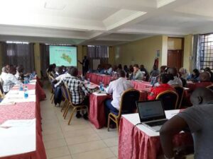 The Amboseli Ecosystem Management Plan 2020-2030 is the second AEMP after the lapse of the first ten-year AEMP 2008-2018. This AEMP incorporates lessons learned during the implementation of the first AEMP.
It is a product of broad-based consultations among diverse stakeholders beginning with government entities of national and county levels, the group ranches, NGOs, Hoteliers and Tour Operators.
The stakeholders and especially the CPT who were the Plan Implementation Committee (PIC) members of the first AEMP, brought up diverse views, expertise and a plan foundation report describing biophysical and social components necessary to achieve the desired future conditions for community livelihoods, ecology, tourism, and institutions and governance systems in the Amboseli ecosystem. The report set out the strategic principles and socioecological relationships, and rationale for development of the new AEMP.
The plan foundation report was an update of a previous report that was used to develop the AEMP 2008-2018. It pinpointed threats to the productivity and viability of the Amboseli ecosystem and national park, the main threats, such as increasing farming, settlement, fencing, subdivision, water extraction from rivers and swamps, the loss of seasonal grazing grounds and drought refuges for livestock and wildlife, and heavy grazing pressure which was reducing the productivity and resilience of the ecosystem.
The threats also included bush meat poaching, a breakdown of migrations and compression of wildlife (elephants especially) into Amboseli National Park, and the resulting loss of habitat and species diversity.
It further recommended specific actions to combat the threats and the creation of Amboseli Ecosystem Trust (AET) to oversee the implementation of the plan. The updated report is the foundation of the new AEMP, and Amboseli ecosystem stakeholders built on this foundation to develop the new plan.
The AEMP 2020-2030 has a wide scope which includes livestock development, rangeland and water management, agriculture, permanent settlements, and urbanization and new enterprises. It also addresses the changes over the last decade and the threats to the ecosystem.
These threats include land subdivision, agricultural expansion, water extraction for farming and other commercial activities, loss of seasonal pastures, and the growing impact of grazers and browsers on habitat, species diversity, and plant production and on livestock and wildlife populations.
As a follow up of the AEMP 2008-2018, the aim of which was to maintain habitat connectivity and safeguard the viability of the Amboseli migratory wildlife populations, the new AEMP strives to maintain and restore ecosystem integrity to safeguard Amboseli’s wildlife and community livelihoods based on the Minimum Viable Conservation Area.
The ecosystem plan also spells out the role of AET and partnering organizations in presiding over the plan implementation, and defines the central role of the Noonkotiak Resource Centre as the information and research hub of the ecosystem, coordinating ecosystem monitoring and planning, setting up an information database, tracking and adapting management plans and developing a visitor and cultural centre and education outreach program.
The AEMP 2020-2030 integrates the land use plans of the seven group ranches, Olgulului/Ololarashi, Mbirikani, Eselenkei, Kuku, Rombo, former Kimana group ranch and Amboseli National Park. Group ranch land-use plans have been developed to minimize land use conflicts and enhance community livelihoods.
The plans consider facilitating conservation of viable wildlife populations at the ecosystem level by planning for wildlife migratory routes and critical refuges. They also include restoring degraded lands through “Olopololi” (grass banks), resting and rotation of pasture use, soil erosion control measures and establishment of wildlife conservancies.
A visit to the American Dust Bowl 80 years on: lessons for the African savannas
A visit to the American Dust Bowl 80 years on: lessons for the African savannas
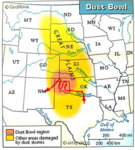 I wrote a couple of articles in Kenya’s Nation newspaper during the 2000 millennium drought warning of worse times to come unless we took steps to arrest the impact of land subdivision, settlement and farms on the pastoral and wildlife lands of the East African savannas.
In the coming years as the degradation worsened and droughts intensified, I pointed to the lessons we could learn from the tragedy of American Dust Bowl in the 1930s.
Timothy Egan’s The Worst Hard Time: The Untold Story of Those Who Survived the Great American Dust Bowl is a fine first-hand account told by the survivors. The Great Plains—the American Serengeti as it has been called–had for millennia been home to millions of bison, elk and prong horn antelope and the Comanche, Arapaho and other tribes who hunted them.
The high plains in the southwest were the last of the American prairies to be carved up and handed out to homesteaders in late 19th century. Following the extermination of the bison and incarceration of the plains Indians in reservations, homesteaders lured by cheap land, ready bank credits and a quick fortune from the booming wheat and cattle markets arrived in the tens of thousands to farm the prairies.
The story goes that cattlemen and farmers—sod-busters as they were called—settled the plains in a wet period, overused the land and destroyed the grass cover binding the fragile soils.
The wheat and cattle boom deflated with the return of dry years and plunging crop and beef markets. Farmers plowed more land to cover their loses and by 1934 the barren land began to lift, creating huge dusters, black blizzards and drifting sands. Over 2 million people were displaced in a humanitarian disaster that helped topple President Herbert Hoover and usher in F D Roosevelt who mobilized thousands of young men to plant trees and stabilize the prairie soils.
What had happened to the degraded land since the Dust Bowl era? What became of the family farmers, herders and wildlife? And what lessons did the prairie Dust Bowl offer the African savannas?
This was a story worth pursuing, yet oddly I could find little about the Dust Bowl or the settlers after the tragedy. In March of 2019 I paid a visit to the Texas-Oklahoma panhandle at the epicenter of the disaster to find out. My drive took me through the worst hit of the Dust Bowl regions—Arnett, Shattuck, Higgins, Glazier, Canadian, Miami, Pampa, Amarillo, Channing, Dalhart, Boise City, Clayton and Springer.
I start out from Norman south of Oklahoma City and travelled along route 40 where the land turns drier, the grasslands sparser and the ground barren. In Clinton where I stop off to refuel, the town, like others along the route, is shedding population and businesses like autumn leaves and homes are decaying like inner-city ghettos.
Half the stores and businesses in Elk City, where I haul in for coffee, are shuttered. A solitary visitor drops by in the half hour, I spend chatting to the owner. Sayr, where I turn north onto 283, is ghostly quiet. The stores on the main street are derelict. All but two gas stations are boarded up for lack of custom. At the historical museum, General Custer is more celebrated than the homesteaders who survived the Dust Bowl tragedy and the first settlers, the Indians who occupied the Great Plains for millennia beforehand.
On the drive through Black Kettle National Grassland reserve, I pass through areas heavily battered and degraded in the 1930s. Dozens of farms are abandoned, homes are crumbling, and fields are being recolonized by bunch grass and scrub too coarse and dry to see a cow through winter.
The small holdings have been bought out by large farming conglomerates which have defeated the hostile climate by drilling deep down to the Ogallala Aquifer and using the energy of fossil fuels pumped from yet deeper into the earth to power huge articulating irrigation booms which water circular fields of cattle fodder, maize, wheat and cotton.
Oil rigs by the hundreds dot the farmlands and supplement corporate incomes from corn and beef trucked to distant American families. Despite its name, Black Kettle Grassland has restored little natural grassland. Large irrigated farms blanket the landscape and dwarf the national grasslands bought up by Roosevelt during the New Deal to relieve destitute farmers.
Up the road from Channing hay fields give way to corn as I approach Dalhart. Dalhart, sitting at 4,600 feet above sea level, averages less than 14” of rain. Unlike the tropics where rainfall increases with altitude, the cold and wind of the high plains shorten the growing season. It takes deep corporate pockets and oil from dozens of rigs to capitalize the heavy-duty tractors, combines and fertilizers needed to grow a bounty of corn and wheat in an area where American family farmers failed to make a living in the Dust Bowl days.
I drive to Boise where only a few scattered tracts hint at the once endless prairies among the large commercial farms. I spot only two herds of prong horned antelope in the remnant grasslands where tens of thousands once roamed. My next stop, Boise City, is fast becoming a ghost town where hospitals, churches, meeting halls and whole streets are abandoned and shuttered. The town is graveyards of old cars, truck, tractors, combine harvesters and metal grain silos.
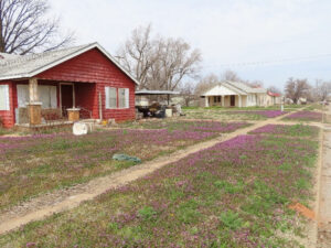
Like so many dying towns in the Texas and Oklahoma Panhandle, human graveyards are filling up as the towns empty out. How sad and morbid driving past the derelict homes of families who once worked the land, loved, married, and raised children here, only to watch their way of life vanish and their youngsters move to the cities.
I check into the Kokopelli Lodge in Clayton for the night after driving through intensively irrigated flat and featureless land with not a tree in sight, except where some homesteader planted a few as windbreaks around a small clapboard cabin. Today the houses are few and far between and sizeable, used by managers who tend the farms and drive the plant. With every aspect of farm production, harvesting, marketing and distribution closely monitored and analyzed by GPS devices and computer programs, farming today is technocracy rather than husbandry.
Nearing Clayton, I turn off the highway to check out a vast feedlot of some 10,000 cattle packed belly to belly in 50 acres of paddock. “This is the dinner you eat,” reads the sign at the entrance to the factory farm. The stench is so strong from the slop of mud and dung that I stop for a quick snapshot and rush on for fresh air. If the smell was served up with every slab of beef and hamburger in homes and restaurants, America would banish factory farms.
Clayton, unlike the other victims of depopulation on the High Plains, shows signs of renewal among the shuttered buildings as visitors keen to get a feel of the pioneer days stop by overnight.
The drive to Springer climbs steadily to 5,800’. Extensive grasslands stretch to a low ridge of hills to the north. The scene resembles Serengeti looking across to the Nabi Hills, the more so for a herd of pronghorn antelope grazing the shortgrass plains. The plains are the epitome of the abandoned dust bowl scenes, minus the wind-swept sands.
Widely scattered abandoned homes with a few spindly trees and crumbling windmills dot the high plains. Life must have been a lonely and spartan for the Dust Bowl survivors who hung on after the destitute families drifted away. The ranches nowadays run to thousands of acres with barely a cow and never a herder in sight. I don’t see a single person on the 60-mile drive to Springer at the end of my Dust Bowl tour with much to reflect on.
The damage caused by the spread of European colonialism around the world and across the US prompted President Roosevelt to convene the Conference of Governors on the Conservation of Natural Resources in 1908. In his opening address he asked, “what will happen when our forests are gone, when the coal, the iron, the oil and the gas are exhausted, when the soils shall have been still further impoverished…We began with soils of unexampled fertility land, and we have so impoverished them by injudicious use and failing to check erosion that their crop-producing power is diminishing instead of increasing.”
Yet the very next year, in 1909, a Soil Bureau’s statement read: “The soil is the one indestructible, immutable asset that the national possess. It is the one resource that cannot be exhausted; that cannot be used up”. This view was contested by experts, including High Hammond Bennett, who warned of the devastation homesteaders and farmers would cause on the high plains, and with good reason.
The grasslands rise from 2,000’ to over 6,000’, have sparse sporadic rainfall, periodic droughts, searing heat and hurricanes in summer and bitter cold spells and blizzards in winter. The plains are treeless and parched dry most of the year with little drainage or surface water. Most rains fall in spring and summer when high temperatures and wind reduce infiltration and water-use efficiency.
The plains in the heyday of the bison herds were dominated by grama-buffalo grass, wire grass, bluestem bunch grass and sand grass-sand sage. The soils are largely loess, remnants of the windblown soils of the post-glacial period held in place by an overburden of thin organic soils bound by plant roots. Beneath the loess is a minerally-leached calcareous hard pan.
The roots trapped the moisture and held the soils in place during the heavy seasonal grazing by migratory buffalo herds. The desiccation of plant and water would have given the grasses a long rest period after the bison retreated to their winter grounds.
Despite the warnings, the federal government was so intent on exploiting the last of the open prairie lands after the army defeated the Apache, Comanche, Kiowa, Cheyenne and Arapahoe that it granted 320 acres of land to settlers under the Enlarged Homelands Act of 1909.
Ignoring the marginal conditions, hostile climate and vulnerability of the high plains to overuse, settlements in the Llano Estacado in eastern New Mexico and northwestern Texas doubled between 1900 and 1920 and accelerated again in the 1920s with a rise in cereal prices on the world market and a run of good rainfall years. Hannah Holleman in her recent book, Dust Bowls of Empire, agrees with Donald Worcester’s classical account in Dust Bowl: The Southern Plains in the 1930s: the immediate causes of the Great Plains disaster were market forces, tenant farmers replaced by mechanization, overextended credit, injudicious land clearing and farm practices, drought and the natural vulnerability of the high plains—the ultimate forces capitalism and agro-industrial farming.
 The phases of agricultural intensification are still detectable in the dilapidated homesteader shacks, in the farmhouses of wealthier ranchers and farmers who bought them out, and in the industrial farms with their giant pivot irrigation booms watering fertile fields of hay and corn. Industrial farming favors big corporations able to invest in heavy equipment and ride out lean years.
I doubt they would make a go of it either without the extraction of voluminous flows of water from the deep aquifers made possible by cheap oil and farm subsidies paid for by the American taxpayer.
The towns in the Dust Bowl region grew with farm production on the high plains, only to fall on hard times when agrobusiness moved in and cut the labor force to the core. Today the towns no longer have the population or tax base to keep schools, libraries, and fire stations open, or maintain the roads.
The remaining residents are aging and struggling to hold on. Their homes are falling into disrepair, barely distinguishable from abandoned houses. The dying towns are graveyards of rusting farm machinery and acres of abandoned cars.
What of the future?
The Dust Bowl 80 years on is carpeted over with greenery, insulating the earth from the wind-blown erosion. Large areas no longer farmed have reverted to grass and shrub cover reminiscent of the bison prairies though no native in composition.
Dust storms may recur in extreme years, and have a few times since, but only locally and with nothing like the severity of the Dust Bowl era than blew away 75 percent of the topsoil.
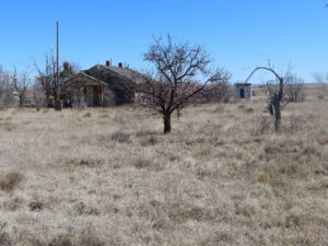 The Dust Bowl was a product of its time, a conflation of human hubris, ignorance, and extreme drought. The land parcels were too small for family farmers to make a living, let alone better lives. Farm technology was a case of too much horsepower for the good of the land in the hands of farmers who lacked familiarity with the earth.
Ironically, it took yet more technology, energy and capital to make the land productive. Agro-industrial farming today has turned a disaster zone into a breadbasket and feed lot for urban America.
I read Donald Worcester’s classic Dust Bowl after my trip to the Oklahoma-Texas Panhandle and agreed with his conclusions after revisiting the area where he grew up:
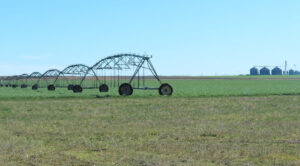 “Capital-intensive agribusiness had transformed the scene; deep wells in the aquifer, intensive irrigation, the use of artificial pesticides and fertilizers, and giant harvesters were creating immense crops year after year whether it rained or not”. According to the farmers he interviewed, technology had provided the perfect answer to old troubles.
The bad old days will not return, they insist. In Worcester’s view, by contrast, the American capitalist high-tech farmers had learned nothing. They were continuing to work in an unstainable way, devoting far cheaper subsidized energy to growing food than the energy could give back to its ultimate consumer”.
 It seems to me the corporate farmers are also a product of their time, sustainable only as long the oil, aquifers and government subsidies last, the present climatic conditions hold, Americans continue to eat 50 pounds or more of beef each year, and are willing to tolerate the cost of leached fertilizers and pesticides into the landscape and rivers and greenhouse gases into the atmosphere.
When subsidies, diets and climate changes and aquifer sink to uneconomic levels, the high plains will change once more. The future is already emerging in new wind and solar farms and with the new nature sensibilities that attract visitors to enjoy the vastness of the Great Plains and its history.
 Are there lessons from the Dust Bowl for the savannas now being subdivided, privatized, and settled? I think so, in several ways. Perhaps the most important is to recognize that land as a commodity rather than the foundation of a communal way of life that has sustained East African pastoralists for generations is liable to the vicissitudes of market forces and short-term gains. The savannas are in the process of becoming market producers of beef and grain rather than family sustenance and welfare.
As in the Dust Bowl, the private allotments are far too small to support a family. Cattle barons land speculators are eying the fallout of subdivision and degradation. The same exodus of dispossessed families is underway.
It will take the resident families banding together as producer associations and land trusts to use the land sustainably for the benefit of its resident members. Even then, a large-scale emigration from the land to the cities is inevitable in the coming decades as the population grows larger than the land can support–and the younger generation seeks new opportunities.
Education is key to providing a passport to opportunities elsewhere. There is also an urgent need to restore the rotational use of grasslands that sustained pastoral livestock and wildlife for millennia in the East African savannas and to embark on a restoration program for the degraded lands, much as Roosevelt did in the Dust Bowl era.
Tracking pasture conditions and predicting droughts in the Amboseli ecosystem
Tracking pasture conditions and predicting droughts in the Amboseli ecosystem
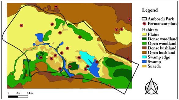
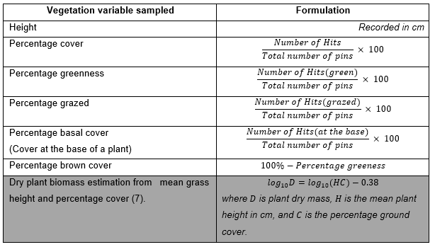
Amboseli Conservation Program has been tracking range-land conditions in the Amboseli region since 1976. The tracking measures plant biomass, greenness and grazing pressure in 20 permanent plots each month in the 700 square kilometer area in and around the Amboseli Basin used heavily by livestock and wildlife in the dry season. The methods used and the results of the long-term monitoring have been published in (Western et al., 2015)
 We have now developed a simplified method of graphically presenting the range-land tracking data to provide group ranch and grazing committees an early warning system indicating the severity of pasture shortage for each year and month.
The method uses grazing pressure on a scale of 0 to 100 as a measure of pasture availability. Zero grazing occurs after good rains and low grazing pressure. To simply the index we use an arrow to indicate the severity of pasture conditions. The arrow in the green range indicates less than a third of the pasture has been grazed down, amber up to two thirds and red severely grazed.
The Illustration 1 below shows the severity of each year from 1976 to 2018. In 1976 pasture was severely grazed down, causing a 50 percent loss of cattle. Grazing pressure was low in the following five years and pastures recovered.
From 1982 onward the grazing pressure increases steadily with shorter intervals of recovery until 2009, the worst year on record when the needle indicates an average of 73 percent grazing pressure. In 2009 over 70 percent of livestock, 50 percent of sheep and goats and large numbers of wildebeest, zebra and elephants died of starvation. From 2010 onward the recovery is far poorer and shorter lived than in earlier years due to heavy grazing pressure.
By 2017 the grazing pressure needle moved into the second highest level recorded. 2018 would have been as severe as 2009 had the drought not been broken by extremely heavy rains. Despite the heavy rains, pasture conditions are shaping up to be very severe in 2019.
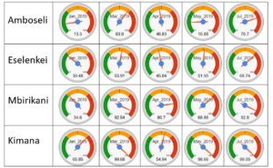 Illustration 2 shows the monthly pasture conditions for 2019 for Amboseli, Eselenkei, Mbirikani and Kimana group ranches. The needle has already moved into the red zone due to poor short rains and heavy grazing pressure.
In the coming dry season Amboseli and all group ranches in the region will experience severe pasture conditions. Unless the region has nonseasonal rains before late September and the pressure relieved by the sale of livestock or outward migration, substantial mortality is likely to occur by October.
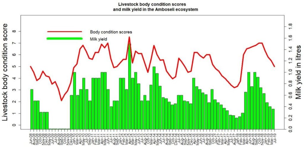
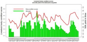 We will be developing and posting tracking details on livestock body condition, milk yields and market prices over the coming month to improve ACP’s range-land monitoring and projections of the seasonal outlook.
Illustration 3 gives a preview of livestock condition and milk production adding weight to the severe outlook for the 2019 long dry season and an early warning of the need for early action to prevent heavy economic losses.
Kenya’s wildlife: A success story still in the making?
Kenya’s wildlife: A success story still in the making?
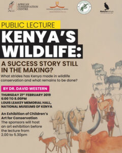 In 1969 Dr. Western gave a public talk at the National Museums of Kenya urging the need to engage communities and general public in wildlife conservation.
Over 50 years later he reviewed the strides Kenya has made yet the continuing failures to halt wildlife declines.
In his talk he reviews how Kenya turn the tide and make its wildlife conservation a real success story.
ACP trains Department of Remote Sensing and Resource Survey (DRSRS) team on open source tools
ACP trains Department of Remote Sensing and Resource Survey (DRSRS) team on open source tools
As commercial software become increasingly expensive, many government institutions across Africawide are turning to opensource applications for data management and analysis. The adoption of opensource technology, raises the challenge of technical skills needed to customize the software to fit organizations’ data needs.
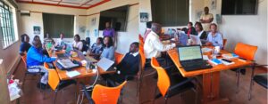 The Amboseli Conservation Program (ACP) has over the years developed opensource technologies for application to various research needs (download paper here). In March 2019 the ACP team in collaboration with the South-Rift Association of Land Owners (SORALO) and the Uaso Ngiro Baboon Project (UNBP) trained the Department of Regional Surveys and Remote Sensing (DRSRS) in the applications of these software tools.
The training sessions covered data management in R, Rstudio, statistical significance testing, mapping and estimations of animal populations and distributions from aerial survey data conducted in Kajiado County, southern Kenya. The training took place at African Conservation Centre offices in Karen.
The tools, which integrate data entry, processing and mapping, can be easily adapted to processing countrywide species population estimates from aerial surveys conducted by DRSRS. Historical counts can also be rapidly processed for spatial trends and subsequent policy advice.
Looking ahead, ACP will expand the training for other conservation organizations to include web applications in R shiny for data analysis, management and mapping. The application requires users to have basic computer skills hence allowing non-technical personnel to interact with and process available institutional data.
Variability and Change in Maasai Views of Wildlife and the Implications for Conservation
Variability and Change in Maasai Views of Wildlife and the Implications for Conservation
 Surveys conducted across sections of the pastoral Maasai of Kenya show a wide variety of values for wildlife, ranging from utility and medicinal uses to environmental indicators, commerce, and tourism.
Attitudes toward wildlife are highly variable, depending on perceived threats and uses.
Large carnivores and herbivores pose the greatest threats to people, livestock, and crops, but also have many positive values. Attitudes vary with gender, age, education, and land holding, but most of all with the source of livelihood and location, which bears on relative abundance of useful and threatening species.
Traditional pastoral practices and cultural views that accommodated coexistence between livestock and wildlife are dwindling and being replaced by new values and sensibilities as pastoral practices give way to new livelihoods, lifestyles, and aspirations.
Human-wildlife conflict has grown with the transition from mobile pastoralism to sedentary livelihoods. Unless the new values offset the loss of traditional values, wildlife will continue to decline.
New wildlife-based livelihoods show that continued coexistence is possible despite the changes underway.
Full article available at https://link.springer.com/article/10.1007/s10745-019-0065-8
Spatial and social ecological dynamics of human wildlife interactions in Amboseli Kenya
Spatial and social ecological dynamics of human wildlife interactions in Amboseli Kenya
 In March, Victor Mose gave a presentation on Spatial and social ecological dynamics of human wildlife interactions at the Institute of Research and Development (IRD) stand at the United Nations Environment Assembly (UNEA-4) in Nairobi.
His talk highlighted the need to factor in the social aspects such as human attitudes towards wildlife in modelling their interactions.
The presentation is part of ACP’s multidisciplinary approach to understanding the drivers of human wildlife interactions and implication for species conservation and coexistence.
The power of visualizing spatial and temporal data in developing and testing ecological hypothesis
The power of visualizing spatial and temporal data in developing and testing ecological hypothesis
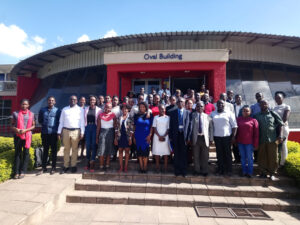 Using exploratory data analysis to visualize and test hypothesis is fast becoming a method of choice for many researchers working across disciplines.
Data visualization allows team members to work together in building ideas about how ecological systems work. Victor Mose outlined the benefits of this approach at the third annual International Biometric Society (IBS)–Kenya chapter held at the Strathmore University in Nairobi.
He used the long-term Amboseli data to show how spatial exploratory data analysis can reduce complex ecological hypothesis to simple visual presentations with cross-cutting research applications.
The approach requires no prior knowledge about the data and can be rapidly applied to formulate and test hypothesis in visual form with wide applications.
Data collection platform for Resource Assessing upgraded
Data collection platform for Resource Assessing upgraded
Following the launch of a digital platform to collect animal and plant data by Amboseli Conservation Program (ACP) last year, the Resource Assessors (RAs) were due for advanced training in the use of digital platform.
This platform now includes livestock herd follows, milk production and market prices recording and general livestock value chain monitoring.
In the first week of September 2018, ACP trained all the RAs working in the Amboseli area on the upgraded tool during a two-day workshop at African Conservation Centre (ACC) offices in Karen, Nairobi.
 The training covered field data capture, checking and online transmission to computer servers at ACC and the processing of results using R scripts for tabular and graphical summaries.
The upgraded platform build on Open Data Kit is more user friendly with meaningful prompts that allow data validation during entry.
At the workshop, RAs and trainers had good discussions and lots of questions asked. The Chairman, ACC encouraged RAs to advance to professional levels in rangeland monitoring through resource assessing.
Data Dissemination
The next step is to implement information feedback to communities based on data collected and to present the analyzed results in a highly visual format that encourages community uptake and decision support, starting at the household level.
The presentation model is based on an open source platform for biodiversity conservation and natural resource management as presented by Mose Victor, Western David and Tyrrell Peter., 2018.
Wildlife survive droughts, livestock suffers
Wildlife survive droughts, livestock suffers
ACP commissioned the Department of Remote Sensing and Regional Surveys to conduct a wet season count of the Amboseli ecosystem in May to take stock of the populations of wildlife and livestock after two years of drought. As reported in earlier ACP web postings, the drought caused the death of livestock and some wildlife species at the tail-end of the long dry season in September and October of 2017.
Given the poor short rains in November and December, we expected drought losses to mount in the January to March dry season this year. The losses were, however, stemmed by unseasonal rains in January and again mid-March.
A comparison of the 2018 counts with the 2017 count prior to the prolonged two-year dry spell shows that, despite the deaths of zebra, wildebeest and buffalo recorded around the Amboseli swamps last September and October, wildlife populations survived the dry years very well. A table comparing the two counts (below) shows zebra, wildebeest, grant’s gazelle, eland and impala numbers holding their own.
Buffalo numbers showed a decline on the aerial counts, but the losses were not evident in the monthly ground counts conducted in Amboseli. Elephant numbers in the ecosystem were down significantly.
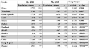 The decline reflects emigration to surrounding areas rather than mortality, given that few deaths were recorded. Giraffe, ostrich and oryx, all drought-hardy species, increased over the past two years. The increase in giraffe is especially encouraging, given its decline across its range in Africa and its recent classification as a threatened species. The increase is due largely to containment of bush meat poaching in the Amboseli ecosystem over the last few years.
The losses of cattle, sheep, goats and donkeys, on the other hand, are confirmed by the mortality records from ground surveys during the drought. Based on our monthly vegetation plots, we expected far larger losses of wildlife than actually occurred.
The wildlife survival we attribute to boost in fresh pasture created by spread of surface water in the swamps in the last two dry seasons. The losses among cattle, sheep and goats was due to the large sizes of their populations and the limited access they had to late season grazing taken up by farms and settlement.
News of Amboseli Conservation Program-related appointments
News of Amboseli Conservation Program-related appointments
Over the years ACP, together with its partner organization, the African Conservation Centre, has taken on and trained over 35 promising conservationists and conservation scientists. Among them was John Waithaka, who conducted his PhD on the impact of elephants on habitats under David Western.
John was later appointed coordinator of elephant programs then director of the Biodiversity Division at Kenya Wildlife Service. John went on become director of ACC before being employed by Parks Canada for fourteen years. On retiring from Park Canada, John returned to Kenya in 2017.
We are pleased to announce that John was appointed the new chairman of the Kenya Wildlife Service on June 1st following the end of Dr. Richard Leakey’s 3-year tenure. John will bring a wide range of experience to his new position and we offer him all our support.
In further government announcement by the Cabinet Secretary for Tourism and Wildlife, David Western was appointed to the Wildlife Utilization Task Force in March 2017. The task force is charged with looking into the pros and cons of various forms of wildlife utilization, including game farming, covered by the Wildlife Act. Sport hunting is banned under the Act and is not under consideration.
In March Sakimba Kamiti, who conducted his Master thesis with ACP, was appointed field coordinator to the joint ACC–University of Lyon 3-year research program into the human dimensions of wildlife and ecosystem changes in Amboseli. Sakimber has also been accepted to PhD candidacy at the University of Lyon, working in collaboration with ACP.
Renewal of the Amboseli ecosystem management plan
Renewal of the Amboseli ecosystem management plan
The Amboseli Ecosystem Management Plan (AEMP) was initiated by ACP and ACC in 2004 to urge the Maasai landowner association to call on Kenya Wildlife Service, other government agencies, conservation organizations, tourism industry and researchers to draw up a conservation plan for the Amboseli ecosystem.
The effort led to the launch a ten year AEMP plan for 2008 to 2018. The aim of ecosystem plan, the first of its kind, was to maintain the viability of the Amboseli migratory wildlife populations.
The plan recognized that pastoral herders also moved seasonally in much the same way as wildlife. With this mind, AEMP defined a Minimum Viable Area for sustaining wildlife and pastoral herds, the threats to the integrity of the ecosystem, and proposed specific mitigation measures.
The renewal of AEMP for a further 10 years is currently underway. ACP has, as in the original planning process, drawn up a detailed report providing the background materials for the new. The report was completed in April and submitted to the planning committee overseeing AEMP 2018-2028.
The ACP report points out that the new plan must take into account the recommendations of the Strategic Environmental Assessment commissioned by the Amboseli Ecosystem Trust and gazetted by the National Environmental Management Authority.
The new plan must also include plans for livestock development, rangeland and water management, agriculture, permanent settlements, and allow for urbanization and new enterprises. The plan should also address the changes over the last decade.
The threats detailed in the ACP 2007 report, which have intensified since then, include subdivision, agricultural expansion, water extraction for farms and development, a loss of seasonal pastures, and the growing impact of grazers and browsers on habitat, species diversity, plant production and on livestock and wildlife populations.
Poaching has declined to manageable levels since 2008, due to the formation of a large well-managed community ranger force. Human-wildlife conflict has, however, risen sharply to the point of undercutting gains in community-based conservation.
 The social, economic and demographic changes underway among the predominantly pastoral community of the Amboseli ecosystem are causing fundamental changes in livelihoods, both out of necessity and choice.
In the long run, social and economic development is likely to relieve the pressure on land. Meanwhile, for the many pastoralists who remain herders, land subdivision, sedentarization and a loss of seasonal grazing decreases their mobility, herd sizes and resilience to drought.
The same pressures pose severe threats to wildlife and intensify competition between people and wildlife over shrinking space and resources.
The land use changes call for reducing the Minimum Viable Conservation Area (MVCA) to exclude heavily settled and farmed areas and focusing on the open rangelands still supporting free-ranging wildlife and livestock. The redefined MVCA is given in below.
Ecosystem planning and coordination framework
Ecosystem planning and coordination framework
At the time AEMP 2008-2018 was drawn up there was no governance structure in place to oversee and coordinate the plan. AET was set up nearly three years after the launch of the plan, faced considerable resistance from conservation organizations, lacked funds for implementation and took time to establish itself.
Subsequent threats to the Amboseli ecosystem, including a Nairobi Metropolitan Area on the border of the park, a public highway cutting the migration routes and a rush to develop new lodges, gave AET a central role in coordinating the responses, overseeing the Strategic Environmental Assessment and the gazettement of AEMP.
The need for an integrated land use and natural resource plan pointed out in the SEA report further reinforced the role of AET. Recognizing the role of the Kajiado County in spatial planning and the communities in land use plans under the Community Land Act, AET has assumed the central role in planning and coordinating the AEMP for 2018-2028.
The revised AEMP must confront the biggest threats to the seasonal movements of pastoral livestock and wildlife, subdivision, sedentarization, and the breakdown of traditional grazing rotation causing land degradation and falling productivity of the rangelands. Alarmed by the loss of pastoral lands following the subdivision of Kimana, the area MP, MCAs and community leaders urged the group ranches to halt subdivision and look at alternatives for keeping the land open for livestock production.
The rapid deterioration of pasture caused largely by a breakdown in grazing management has spurred efforts to restore governance of seasonal grazing practices, pasture productivity and livestock marketing.
A number of group ranches have begun to conduct land use plans, reestablish traditional grazing committees, rotational herding practices and establish conservancies in response to the worsening range and livestock conditions. The plans include restoring degraded lands through olopololi (grass banks), resting and rotation of pasture use, soil erosion control measures and designated wildlife conservancies. Integrated group ranch plans offer the best hope of avoiding a Kimana-like loss of pastoral lands and finding space and a place for wildlife in the pastoral rangelands.
Ogulului and Kuku have recently completed land use and grazing plans and embarked on restoration plans funded by Just Diggit. Mbirikani is in the final stages of completing its own land use and grazing plans.
Selengei has embarked on similar plans and Rombo is following suit. All the group ranches in the Amboseli ecosystem have agreed to integrate and coordinate their land use, grazing and restoration plans through the Rangelands Division of AET.
Degradation a threat to Kenya’s Rangelands
Degradation a threat to Kenya’s Rangelands
Degradation, subdivision and skyrocketing demand for land is threatening Kenya’s rangelands. This was raised during a two-day Rangelands Communities Exchange Conference held in Nairobi convened by the Rangelands Association of Kenya in collaboration with African Conservation Centre and International Livestock Research Institute (ILRI).
“Mobility is the basis of productivity in Kenya’s rangelands where livestock and wildlife coexist. You can’t have a herd without grassland” Chairman African Conservation Centre, David Western said. “Grassland in Amboseli has degraded so much that today, there is 30 percent less grass produced for the same amount of rainfall than it was in the 1960s.
In northern Kenya the amount of pasture produced today is 40 to 50 percent less than that produced five decades ago for the same amount of rainfall” He continued. Download full article here.
Recovery from 2009 drought but another to come
Recovery from 2009 drought but another to come
2017 saw a continuing recovery of Amboseli wildlife numbers after the precipitous losses in 2008, as shown in Figure 1. The slow recovery of zebra and wildebeest, held in check by predation until 2012, began to accelerate through to 2017 once the herds resumed their strong seasonal migrations.
Zebra and wildebeest numbers tracked each other closely throughout the recovery. The downturn in the 2017 dry season may reflect fewer animals returning to the basin rather than a decline in population. Buffalo numbers remained low until 2015 when the herds began migrating with the rains to avoid heavy predation pressure and now stand at three quarters of their pre-drought levels.
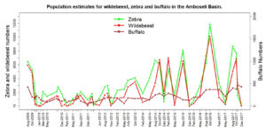 Elephant numbers which peaked at around 550 in the Amboseli Basin in the late 1980s following a concentration in the park following the heavy poaching of the 1970s, declined steadily to a low of 300 at the beginning of the 2009 drought.
 After the loss of over 400 animals, the elephant numbers returned to a high of over 550, then fell strongly to an all-time low of a little over 200 with the resumption of drought in 2017 when little forage remained in the swamps.
Sheep and goat numbers climbed to 179,000 by November 2017 when ACP commissioned a count of the Amboseli ecosystem, considerably down from a peak of 341,000 in 2016.
Cattle numbers are also down after peaking in 2016, from 127,000 to 55,000. ACP uses many indicators to track and anticipate severe conditions. In addition to the numbers of wildlife and livestock, other measures include pasture abundance, the body condition and milk yields of cattle (Figure 2) and market prices (Figure 3) which slump in times of drought.
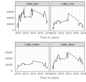 Taken collectively the data show the build-up of wildlife numbers and recovery of livestock condition after the 2009 drought and point to a repeat severe drought setting in late 2016 and early 2017. The declining conditions are reflected in livestock milk yields, body condition and market prices. Result are not yet in from mortality figures but for cattle are likely to be around 40 percent so far.
The 2017 short rains were forecast to be good and widespread but have been desultory and scattered over much of southern Kenya, including Amboseli. Large numbers of zebra and wildebeest carcasses have been counted around the Amboseli swamps.
With the paltry rains and failure of grass to recover after years of heavy grazing, the drought conditions are likely to become extremely severe before the long rains of April 2018.
Meeting the new governor of Kajiado
Meeting the new governor of Kajiado
The newly appointed governor is Joseph Ole Lenku, former Cabinet Secretary Defense and highly influential in the Kenyatta government. His tenure sees a virtual clean sweep for Jubilee Party in Kajiado. Hon Lenku is from the Amboseli area and no stranger to the issues there, especially the human-wildlife conflict and suffering of pastoralist in droughts.
He came out with a scathing indictment in a two-page piece in the press of wildlife conservationists ignoring the suffering of pastoralists and farmers. The article sent ripples through the NGO sector and KWS. Fortunately, I got to see him shortly after his induction, accompanied by Benson Laiyan, coordinator of the Amboseli Ecosystem Trust, chairman of the Trust, Daniel Lolteris, a close ally of Lenku’s. Jackson Mwato and Johnson Sipitiek, both ACC community officers.
Over the course of an hour I was able to explain to the governor the collaborative efforts in Amboseli and how the community, with its NGO partners and KWS, is addressing the very issues he raised. I also pointed out the underlying causes of the recurring droughts being grazing pressure, and the need to institute land use plans, grazing plans, restoration efforts and livestock development and marketing programs.
The governor was persuaded, it seems, especially by the inputs from the Amboseli community. He has agreed to come down and launch the women’s milk cooperative ACC set up and the Nongotiak Resource Centre. He has since taken on Benson Laiyan, Coordinator of the Amboseli Ecosystem Trust, as his right-hand person on project delivery. Benson made a start on the governor’s promise of support by bringing down the new county head of Lands and Livestock to an AET meeting last week.
The governor’s support holds promise of getting solid attention to the land, grazing management and degradation issues the previous administration had difficulty tackling. He has announced that he will set aside all country holdings as grass banks for supplementary fodder during droughts.
Threats to the Amboseli ecosystem
Threats to the Amboseli ecosystem
Land subdivision and permanent settlement
The biggest threat to the viability of the Amboseli ecosystem and the free-ranging wildlife herds of East African savanna ecosystems in general is land subdivision.
I have raised concerns in published articles based on the Amboseli long-term monitoring program showing the impact of subdivision of group ranches on habitat and wildlife (2009’ Western, D Groom, R and Worden, J. The impact of land subdivision and sedentarization of pastoralist on wildlife in an African savanna ecosystem.
Biological Conservation 142: 2538-2546; 2013. Groom, R.J. and Western, D. The impact of land subdivision and sedentarization on wildlife in Kenya’s southern Rangelands. Rangeland Ecology and Management 66(1): 1-9).
The threat grew with the clamor for subdivision on the group ranches across the Amboseli ecosystem. Fortunately, the large fallout from the resale of Maasai lands resulting from the subdivision of Kimana Group Ranch led Maasai leaders to call a halt and take stock of other land use options. The halt led to Mbirikani asking ACP and ACC to draw up land use plans for the group ranch.
ACC raised the funds from GEF to conduct the land use plan, and Big Life funds from the same sources to conduct a grazing plan. ACC employed rangeland consultants to conduct the plan working closely with ACP. The plan was completed in September and is awaiting ratification from the group ranch committee. ACP contributed most of the background data.
ACP also played a lead role in recommendations for the grazing plan, based on traditional seasonal movements and grass banks governed by grazing committees. The grazing plan is in draft stage ready for group ranch review.
In a serendipitous development, the recent Community Land Act halts all further subdivision of group ranches, pending registration of all members, including women. The registration of women will in itself put a break on subdivision. Further, the Act calls for all group ranches to draw up land use plans.
This puts the Mbirikani land use and grazing plan ahead of the curve and an example for others to follow. Selengei Group Ranch has also approached ACC to conduct a land use plan of the ranch and the exercise is underway. ACP is providing the background and framework for the planning exercise. With land use and grazing plans underway on Mbirikani and Selengei and Ololorashi Ogului scheduled to follow, most of the Amboseli ecosystem will be under formal land use plans, which will be incorporated into the Amboseli Ecosystem Management Plan 2018-2018 scheduled for review in 2018.
The county governments are, under the new constitution, mandated to do spatial planning. The 2008-2018 Amboseli Ecosystem Management Plan was formally adopted by the Kajiado County and gazetted by the Attorney General’s Chambers. AEMP, the first of its kind, is viewed as a model for other ecosystem development plans and has been adopted by KWS as a framework for wildlife planning around and beyond parks.
The new governor of Kajiado has given his backing for the land use planning exercises. He has also announced that the county will zone the district into areas for settlement, agriculture and livestock-wildlife use and prohibit the sale of the mixed-use rangelands. This is excellent news and just the step needed to halt the subdivision of the rangelands.
In a further promising development, the range lands division I have been pushing for AET to establish to oversee the planning and integration of all aspects of livestock and wildlife development was approved by the board of AET in November. I was appointed interim chairperson to give direction and weight to the new division. We held our first meeting on December 7th.
The division will encourage and oversee land use plans, grazing management, water plans, livestock improvement schemes, the newly established Women’s Milk Cooperative, marketing, range land restoration and outreach programs for the group ranches under AET. The county and central government range lands officers will set as ex-officio members on the board.
Pasture degradation in the Amboseli ecosystem
Pasture degradation in the Amboseli ecosystem
The degradation of pasture documented by the ACP long-term monitoring program is widespread across the Kenya and northern Tanzania rangelands. The Dutch group NAGA funded AET in collaboration with ACC and ACP, to conduct a pilot restoration program on the group ranches using the traditional Maasai olopololi method of grass banks, as reported in the year-end LCAOF report for 2016 and on the ACP website.
The pilot program was considered extremely successful and formed the centerpiece of a NAGA submission to the Rabobank in Holland to fund a multi-year restoration program in Kenya, Tanzania and Brazil. I met up with the Rabobank assessment team in September and gave a background to rangelands degradation in Kenya and the steps for restoration.
The NAGA group (now called JustDiggit) won the award against a very competitive set of submissions. The group advanced a $70,000 grant ACC and AET in October to set up an interim program and draw up a long-term ecosystem-wide program by March. The JustDiggit team met with AET, ACC, ACP and other NGOs on December 8th to draw up a schedule for completing a detailed restoration plan.
The restoration plan will be a multi-year initiative covering the Amboseli ecosystem, south rift and adjoining Tanzania borderlands. The program, to be launched in May 2018, will be overseen by ACC and managed by AET and conservation partners.
In another development, the governor of Kajiado, following the details I gave him on the cause and extent of degradation across the county, has announced he will use all the county’s land holdings as grass banks to provide hay during droughts. The Maasai across Kajiado were buying substandard hay at exorbitant prices from Western Kenya over the last three months.
The magnitude of pasture degradation is finally being acknowledged as a national disaster underlying cause of dislocation and conflict between neighboring tribes in northern Kenya and the deepening the conflict with wildlife. In 2017 the Kenya government signed onto the AFR 100 Pan-African agreement recognizing the severity of land degradation.
It has committed itself to restoring 5.3 million hectares of rangeland. The World Resources Institute (WRI) assisted the government in identifying potential restoration sites and is using the Amboseli program as a template for scaling up nationally. WRI is keen to work with ACC in designing the national program. I gave a talk to WRI in Washington DC in October and suggested the need for a national restoration strategy, modelled on the National Wildlife Conservation Strategy the ACC is coordinating on behalf of the Ministry of Environment.
WRI partnered ACC’s preparation of Kenya’s Natural Capital: A Biodiversity Atlas. As a follow up of the October meeting, WRI will fund ACC to draw up a national restoration strategy under the Ministry of the Environment and in collaboration with the Rangeland Association of Kenya.
Amboseli takes a lead in addressing human-wildlife conflict
Amboseli takes a lead in addressing human-wildlife conflict
The severity of conflict between wildlife and people intensified with scanty short rains in November and December. The conflict was the main topic of discussion at a meeting of the Borderlands Conservation Initiative, held in Nairobi in 1st and 2nd of March. Wardens, county representatives, conservation organizations and researchers reviewed the scale of conflict in Kajiado and Narok counties and mitigation measures.
Amboseli was highlighted as the best documented case of the rising conflict as poaching abates and wildlife expands into human habitation. The following excerpts summarize the findings of BCI meeting:
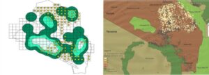 Between 2013 and 2016, 40 human deaths and 300 injuries caused by wildlife were reported in Kajiado, along with 1,700 crop raiding incidents. Many incidents go unreported by farmers who feel there is no hope of getting any compensation.
Big Life noted that the growing number of human deaths from elephant attacks has caused a spate of retaliatory spearing by young warriors. Only one elephant was lost to poaching in in Amboseli during 2016, compared to 24 to 30 elephants killed in retaliation. Big Life attended 145 crop raiding incidents in Amboseli area last year.
The growing overlap of elephants and small-scale farms (shambas) was presented by the Amboseli Conservation Program:
Big Life profiled the distribution of conflict incidents for 2016. Big Life deploys 60 of the 350 Amboseli community scouts in conflict mitigation. Many farms are isolated and difficult to protect. The average damage per person is 0.5 acres and the interception rate on crop-raiding elephants on the order of 60 percent. Retaliatory incidents have risen sharply, posing dangers to scouts and rangers who intercede.
The BCI meeting concluded that the growing conflict needed to be tackled locally rather than rely on government compensation, and through land use planning at a county and group ranch level. Amboseli was highlighted as an example of the steps needed to address human-wildlife conflict.
 A follow-up meeting of the Amboseli Human-Wildlife Conflict Committee set up in December was held at the Kenya Wildlife Service headquarters on the 22nd March. The meeting, convened by the Amboseli Ecosystem Trust, included the district police and National Intelligence Service, in addition to KWS, community leaders, conservation organizations and researchers.
The meeting reached a consensus on a preliminary draft of rapid-responses protocols for dealing with human deaths and injuries caused by wildlife. Kenya Wildlife Service, as the agency responsible for wildlife, will set up a hotline for reporting incidents. Big Life, which has an area-wide radio network, will send out the alerts via Whats App to assemble the rapid-response group on site.
The Amboseli Ecosystem Trust will sound out the communities on the protocols being drawn up by the Amboseli Trust for Elephants, Lion Guardians, Big Life, ACC, KWS and the County Wildlife Compensation Committee Chairman. ACP will set up technical group to compile a human-wildlife conflict database.
Other measures to address the conflict are underway. Conservation organizations, Amboseli Ecosystem Trust and KWS have held meetings with warrior and youth groups in the Amboseli region to address the conflict:
- In January ACC gave start-up funds to launch conservation education outreach program in memory of Josh Kirinkol ACC US board member, aimed at engaging the younger generation of Maasai.
- ACC, funded by the Global Environmental Facility, is undertaking land use planning on Mbirikani, Kuku and Rombo group ranches. The land use plans zone each ranch into areas for settlement, farming, commerce, extensive livestock-cum-wildlife, ecotourism and conservancies.
- Big Life has completed 48 kilometers of an electric fence to protect the main farming areas east of Amboseli and along the foot-slopes of Kilimanjaro from elephant raids. The fence is proving highly effecting in keeping elephants out of farms.
Community perceptions on rangeland resource dynamics in Amboseli
Community perceptions on rangeland resource dynamics in Amboseli
In November 2016, Sakimba Kimiti, a research assistant with the Amboseli Conservation Program, defended his master’s titled, Rangeland Resource Dynamics and the Implications for Pastoral Livelihoods in the Amboseli Ecosystem, Kenya.
Sakimba was interested in describing the local community knowledge, attitudes and perceptions of the extent of change in rangeland resources in Amboseli. Changes in the ecosystem monitored by ACP over the last few decades include land fragmentation, loss of grazing areas, changes in land tenure, restricted herd mobility due to increase in human settlements, changes in land use, and loss of pasture productivity.
How well do local perceptions reflect the changes, and what is missing in the changes measured? Few studies have compared traditional and scientifically monitored information.
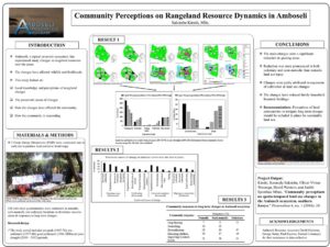 Sakimba integrated scientific approaches and local knowledge to assess changes in the Amboseli ecosystem over time, the causes of changes and the impact of the changes on pastoralists.
He stratified the Amboseli ecosystem into nomadic, semi-nomadic and sedentary land uses under group tenure and private holdings. The four decades of change were divided into a pre-park period (1967-76), pre-settlement (1977-86), post-settlement (1987-2006) and the post-2009 drought.
From the resource maps drawn by the community, grazing areas have declined significantly over the period. The decline was more pronounced in the sedentary subdivided lands and the semi-nomadic locations, less so in nomadic locations.
Areas of cultivation have also expanded over the period in both sedentary and semi-nomadic land sites. The changes have led to a reduction in household herd size in all the land locations, with the biggest declines in the sedentary land use sites.
The results of the study show that pastoralism remains a key livelihood strategy in Amboseli. Monitoring rangeland changes through community perceptions is a vital step in designing sustainable strategies for managing change and in strengthening participatory planning process.
Click link for full paper
Community perceptions on spatio-temporal land use changes in the Amboseli ecosystem, southern Kenya
ACP launches digital platform to collect animal and plant data
ACP launches digital platform to collect animal and plant data
The Amboseli Conservation Program (ACP) on Wednesday 22nd March 2017 launched an all-digital data collection platform that Resource Assessors (RAs) will use to collect and transmit both plant and animal data in the Amboseli ecosystem.
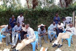 The platform, called ODK (Open Data Kit), will help generate the first comprehensive ecosystem wide data set of ground sampling for wildlife, livestock, plants, settlement mapping, market surveys and drought conditions.
ODK is a free and highly customizable open source set of tools which simplifies collecting data in the field and aggregates the information on a remote server. Using the platform, ACP can now upload monitoring data onto a tablet in the field. The tablet also logs GPS location, date and time and takes digital pictures.
The data is transmitted through the cloud for instant retrieval, updating and analysis on any database. The ACP database has integrated an analysis tool developed in R that analyses and generates instant results.
The digitization of field data and cloud transmission frees up time for Resource Assessors in the field and data analysts in the office to review the results and communicate the findings to user groups.
“I now wouldn’t need to carry my camera and GPS as the platform incorporates them both.” said an elated Maitumo, a long serving RA for the Amboseli Conservation Program.
The urgency of resolving human-wildlife conflict
The urgency of resolving human-wildlife conflict
Predator attacks on livestock continue at a high level, despite the increase in wildlife numbers showing up in the ecological monitoring. This suggests that carnivore stock-killing is becoming habitual when wild prey availability should see attacks falling.
The reasons likely stem from the loss of herding skills and knowhow in dealing with predators, resulting in the loss of hundreds of straying animals. Five lions have been speared in the Amboseli area in 2016, the highest in several years.
The spearing, reported by Lion Guardians at the Human Wildlife Conflict (HWC) group, point to the anger communities feel about the failure of compensation payments, the slow response to conflict incidents, and warriors building up for an age-set ceremony shortly.
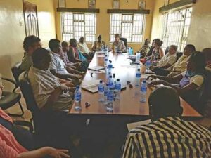 Crop depredations by elephants are also at an all-time high. Human deaths due to wildlife attacks have caused several riots in the Amboseli region this year.
The same underlying causes of anger over lion depredations are fueling angst over elephant crop raiding, made worse by the loss of human life. Elephants have made ten fatal attacks on people in the Amboseli area this year.
The lax responses to the attacks, added to the lack of compensation, has turned a bad situation serious. In one incident a few weeks ago, the body of a victim lay unattended by government officials for three days and was eaten by lions, hyenas and a leopard.
The community took up spears in retaliation and KWS was forced to kill an innocent elephant in reprisal. The killing of innocent elephants is making docile elephants skittish and dangerous, according to Cynthia Moss.
As reported at the launch of the Nongotiak centre in March, the anger and frustrations of the community and the governor of Kajiado, Dr. David Nkedianye, boiled up over the elephant and lion attacks and was directed at the new KWS Director General, Katili Mbathi. The meeting gave the DG a window onto the challenges facing KWS as the elephant poaching crisis subsides.
The bigger longer-term challenges lie in finding space and a place for wildlife beyond parks–and beyond the conservancies–which have been the focus of KWS attention outside parks in the last few years.
A number of developments are underway in Amboseli to address the threats.
Big Life has taken a lead in tackling the depredations of elephants on small-scale farms on the slopes of Kilimanjaro and swamps east of Amboseli. Assisted by Space for Giants, Big Life has drawn up a fencing plan to secure the farms from elephant attacks. The 45 kilometer fence should alleviate most of the depredations on the farms south and east of Amboseli, areas elephants rarely used before farmers moved in.
Most elephants moved north and west of Amboseli with the rains. These areas remain lightly used and could, with the restoration of seasonal dams, reintroduce elephants to their former range.
To address the broader human-wildlife conflict, Lion Guardians, Amboseli Trust for Elephants, Big Life, the International Fund for Animal Welfare, ACC and ACP have set up a HWC mitigation group under the umbrella of the Amboseli Ecosystem Trust. The inaugural meeting was held in March, the first fully-constituted meeting on December 7th 2016
The December meeting was chaired by Jeremy Goss of Big Life and attended by the warden and KWS Assistant Director, Southern, Daniel Onsembe, Benson Laiyan of AET, Daniel Lolterish, chairman of Ololorashi Ogulului Group Ranch, Jackson Mwato, the Kajiado County Wildlife Compensation Committee chairman, Johnson Sipitiek of ACC, community representative, Cynthia and staff of the Amboseli Elephant Trust, Leela Hadza and staff of Lion Guardians, Craig Miller, head of security for Big Life, and IFAW representatives. The main item on the agenda was the growing elephant and lion conflict.
The community members reiterated that the biggest cause of anger and reprisals was the lack of response after an elephant attack on farmers and herders. The warden reported that the only person who can authorize the killing of an elephant, however imminent the threat, is the Director General of KWS.
The long delays inevitably mean the elephant has fled the scene even if action is granted. The upshot is that warriors take up spears and kill any elephants in the neighborhood, or KWS ends up killing the wrong elephant to placate the community when authority is granted.
Daniel Onsembe, Assistant KWS director, joined in the lengthy discussions about the place of dialogue and enforcement in addressing the conflict. After the last lion killing, the warden got the community to fine the warriors in the traditional manner and no lions have been killed since. The warden referred to the bible in one hand and the gun in the other duality of KWS wardens. The bible has proved more effective than the gun, particularly with the Maasai.
Onsembe supported the Warden’s view and said dialogue should be the first KWS response, arrest only when dialogue fails. He noted that KWS doesn’t have the money or manpower to solve the wide-spread conflicts.
The best thing going for resolving the conflict is the “Parks Beyond Parks” movement and conservancies, which put wildlife management into the hand of communities and brings in NGOs in as partners. Johnson Sipitiek, chairman of the Narok County Wildlife Compensation Committee, added that KWS and the Ministry have lost credibility because no compensation for human deaths has been paid in two years and the claims now run at $29 million a year.
At the conclusion of the meeting, the HWC meeting set up a small group, including ATE, Lion Guardians, Big Life, AET and KWS, to propose rapid response protocols. The Amboseli warden will push the protocols with KWS DG, aimed at devolving HWC responses to approved teams that can act promptly after an attack. ACC will also launch a youth education fund in January, directed largely at young warriors, in memory of one of their most ardent conservation advocates who died recently. AET will set up small groups of warriors on each ranch to join the rapid response group attending victims of attacks.
The research and conservation groups agreed on setting up a HWC database with the assistance of ACP. The database will include a deep layer dealing with the long-term and seasonal pressures at the root of conflict—the supply side information–and a top layer dealing with the rapid response information, the demand side of conflict mitigation. The protocol will be presented at the BCI workshop in February for wider discussion and adoption across southern Kenya.
Continued recovery of Amboseli wildlife
Continued recovery of Amboseli wildlife
Wildlife numbers in Amboseli continue their recovery from the 2009 drought. The influx of zebra and wildebeest into the Amboseli basin in October doubled the numbers counted in August.
This is good news for Amboseli and, along with Maaasai Mara, has restored the national park to the top league of wildlife viewing in Kenya. I have not seen such spectacular concentrations of zebra, wildebeest and gazelle around the swamps since the 1990s.
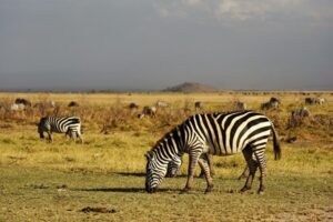 The increase reflect a continuing recovery of herbivores from the 2009 drought in which wildebeest numbers plunged by over 90 percent, zebra by two thirds and buffalo by slightly more. Zebra numbers have recovered their pre-drought levels of 16,000 but are still below their peak numbers in the 1990s.
Wildebeest figures have risen to two thirds of their pre-drought levels and buffalo are approaching the same recovery.
The big influx into Amboseli in October also reflects the severity of conditions across the larger ecosystem, as reported in the July posting. With livestock at peak numbers and the long rains falling short in the Chyulus and Mbirikani, Kuku and Rombo Group Ranches to the West, pasture is at its lowest ebb since the 2009 drought.
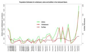 The upshot is a large influx of wildebeest, zebra and livestock that would otherwise retreat to the dry season pastures along the base of the Chyulu Hills. Since July, I have counted the largest numbers of cattle, sheep and goat in Amboseli in many years.
The recovery of wildlife and livestock herds poses big problems that need urgent attention to avoid a repeat of the 2009 drought. The pressure on the pasture is showing up in the monthly grassland plots we monitor across the ecosystem. Grazing pressure has severely depleted the late dry season reserves. Pasture recovery is falling sharply in the rains.
The body condition and milk yields of cattle has dropped steeply, making life harder for pastoralists. Herders are pushing their animals deep into the Chyulu Hills, Tsavo West and Amboseli National Parks in search of grazing, causing a growing conflict with Kenya Wildlife Service rangers.
Elephants running short of late season forage in the park are spreading out of the park and running up conflict with herders and farmers. The intense grazing and browsing pressure in Amboseli National Park is continuing to deplete woody vegetation and biodiversity.
A renewed push to build a cement factory between Amboseli and Mbirikani/Chyulu Hills poses a severe threat to the migratory route connecting the two pivotal portions of the ecosystem.
Measures to conserve the Amboseli ecosystem
Measures to conserve the Amboseli ecosystem
As reported in July, the imminent threats to the Amboseli ecosystem are land subdivision, fencing, loss of habitat due to browsing pressure and pasture due to grazing pressure, and a rising conflict between wildlife and humans.
Predator attacks on livestock continue at a high level, despite the increase in wildlife numbers, suggesting carnivore stock-killing habits are persistent. Crop depredations by elephants are running at all-time high. Human deaths due to wildlife attacks have caused several riots in the Amboseli region this year.
A number of new development have taken place since the July report on measures to address the threats. The most important is the launch of funding for the Amboseli Ecosystem Management Plan. After a year and a half of delays, a four-year grant from the Global Environmental Facility has been released to KWS, African Conservation Centre, Big Life and Maasai Wilderness Conservation Trust.
Each organization will take on specific tasks, aimed at restoring the health of the Amboseli ecosystem. ACC will help build the capacity of the Amboseli Ecosystem Trust to oversee the implementation of the plan.
Preliminary steps to restore the loss of habitat, pasture and biodiversity were undertaken by ACC, ACP, KWS, Big Life under the umbrella of AET in series of woodland elephant exclosures and pasture restoration plots over the last year. The start-up funds were provided by NAGA. Additional funds are provided under the GEF program.
Plans are underway through the partnership headed up by AET to submit a renewed grant application to NAGA for setting up a long-term ecosystem restoration program.
Big Life has taken a lead in tackling the depredations of elephants on small-scale farms on the slopes of Kilimanjaro and swamps to the east of Amboseli. Assisted by Space for Giants, Big Life has drawn up a fencing plan to protect the line of farms from elephant attacks. The 37 kilometer fence should block elephants from reaching the growing farming communities to the south and east of Amboseli, areas they rarely used before farmers moved in.
Most elephants moved north and west of Amboseli with the rains. These areas remain lightly occupied and, could, with the restoration of seasonal dams, restore elephants to their former range.
To address the broader human-wildlife conflict, the main NGOs tackling conflict, including Lion Guardians, Amboseli Trust for Elephants, Big Life, International Fund for Animal Welfare, ACC and ACP will be meeting under the umbrella of the Amboseli Ecosystem Trust and KWS on December 8th to set-up an integrated conflict mitigation strategy and procedures.
Master’s thesis study
Master’s thesis study
In November 2016, Sakimba Kimiti, a research assistant with the Amboseli Conservation Program, defended his master’s titled, Rangeland Resource Dynamics and the Implications for Pastoral Livelihoods in the Amboseli Ecosystem, Kenya.
Sakimba was interested in describing the local community knowledge, attitudes and perceptions of the extent of change in rangeland resources in Amboseli.
Changes in the ecosystem monitored by ACP over the last few decades include land fragmentation, loss of grazing areas, changes in land tenure, restricted herd mobility due to increase in human settlements, changes in land use, and loss of pasture productivity.
How well do local perceptions reflect the changes, and what is missing in the changes measured? Few studies have compared traditional and scientifically monitored information.
 Sakimba integrated scientific approaches and local knowledge to assess changes in the Amboseli ecosystem over time, the causes of changes and the impact of the changes on pastoralists. He stratified the Amboseli ecosystem into nomadic, semi-nomadic and sedentary land uses under group tenure and private holdings. The four decade of change were divided into a pre-park period (1967-76), pre-settlement (1977-86), post-settlement (1987-2006) and the post-2009 drought.
From the resource maps drawn by the community, grazing areas have declined significantly over the period. The decline was more pronounced in the sedentary subdivided lands and the semi-nomadic locations, less so in nomadic locations.
Areas of cultivation have also expanded over the period in both sedentary and semi-nomadic land sites. The changes have led to a reduction in household herd size in all the land locations, with the biggest declines in the sedentary land use sites.
The results of the study show that pastoralism remains a key livelihood strategy in Amboseli. Monitoring rangeland changes through community perceptions is a vital step in designing sustainable strategies for managing change and in strengthening participatory planning process.
One-stop software programs for ecological monitoring
One-stop software programs for ecological monitoring
The slow pace of delivering information to decision-makers hinders its application to conservation planners and managers. ACP is developing a fully integrated Windows database with open source software that will speed up the process and be available to all conservation organizations collecting resource data.
 Victor Mose has in recent months developed most of the software for rapidly entering, analyzing and producing data for use by SORALO, AET, NTRI and DRSRS among others.
The platform includes a GIS and other graphical visualization tools to summarize and display the data; open source analytical and statistical packages for rapid evaluation and application of the data, and spatial tools for assessing the trends, drought early-warning systems and the health of ecosystems.
ACP’s ultimate aim for the integrated ecological monitoring and one-stop software program is to produce regular state-of-ecosystem reports of the Kenya-Tanzania borderlands on a Google Earth image for use by participating NGOs and communities.
Victor Mose used the new software to analyze the Laikipia Wildlife Forum (LWF) wildlife count undertaken by DRSRS in May. Victor presented a review of the integrated analytical software at the fourth Spatial Ecology Conference in July 2016 in Bristol, United Kingdom (see details here). The presentation will be submitted in the December 2016 report.
Amboseli wildlife recovery from 2009 drought
Amboseli wildlife recovery from 2009 drought
The Amboseli Conservation Program (ACP) continues to monitoring wildlife, livestock, settlements and vegetation in the national park and across the ecosystem.
David Maitumo conducts regular ground counts and David Western monthly aerial counts of the Amboseli Basin. ACP also commissioned the Department of Resource Surveys and Remote Sensing (DRSRS) to undertake an aerial survey of the 8,500 square kilometre ecosystem in May.
 The results of the ground and aerial counts are in close agreement, showing strong recovery in wildlife populations over the last three years, following four years of paltry rebound after the population crashes during the 2009 drought.
The recovery of wildlife numbers in the aftermath of the 2009 drought was far slower than in the 1970s drought, due to the larger losses of herbivores and heavier predation levels by lions and hyenas. The lag in recovery shows up in the prolonged low population numbers of zebra, wildebeest and buffalo from 2010 to 2014.
 The small populations of wildlife caused heavy predation on livestock and growing resentment among herders. The last two years have seen a strong recovery in all herbivores once the numbers breached the predation threshold.
The seasonal migrations have also picked up again, as shown in the graph. Of special interest is the resumption of migrations by buffalo, which ceased after elephants open up swamp-edge grazing following compression by poaching in the 1970s. The resumption of seasonal migrations spares buffalo heavy predation in the basin during the rains.
The trends point to a healthy ecological balance returning to the Amboseli ecosystem after the 2009 population crash. With wildlife ungulates approaching their pre-drought levels, carnivores have more wild prey and less need to attack domestic stock. The larger numbers have also precipitate the resumption of strong seasonal migrations during the rains.
The ecosystem-wide surveys commissioned by ACP and conducted by DRSRS in May further confirm the recovery of wildlife numbers. Elephants are back to their pre-drought levels and continue to grow in numbers and expand their range.
Zebra numbers have recovered their pre-drought levels of 16,000. Wildebeest numbers have also picked up in the past three years, but at 9,000 still fall short of the pre-drought levels of 17,000.
Expanding the monitoring program ecosystem-wide
Expanding the monitoring program ecosystem-wide
In March 2015 ACP trained up three additional resource assessors to expand the Amboseli ground monitoring across the ecosystem. The expansion covers Selengei, Mbirikani and Kimana Group ranches. Logistically, the expanded coverage is beyond the capacity of ACP.
For this reason, ACP called on Big Life to administer and oversee the monitoring on Selengei and Mbirikani. ACC provided two motorbikes to enable the RAs to cover the three group ranches.
A Memorandum of Understanding between ACP/ACC and Big Life was drawn up in December 2015. The program was fully operational by December. The ground monitoring now covers the entire Amboseli ecosystem defined by the migratory ungulates.
David Maitumo will continue to mentor and oversee the resource assessor’s field monitoring. The data will be simultaneously logged at ACC and Big Life, and once the Nongotiak Centre is complete at AET.
The final step in setting up and ensuring the sustainability and application of the ecosystem monitoring to planning and management is the preparation of a 5-year MoU between AET and ACP. This will be drawn up once the Nongotiak Resource Centre is complete.
Launch of the Amboseli Nongotiak Resource Centre
Launch of the Amboseli Nongotiak Resource Centre
Following a lengthy engagement of the community, Ololorashi Ogululu Group Ranch set aside land for the Amboseli Ecosystem Trust resource centre at Nongotiak adjacent to Amboseli National Park in 2015.
The land will house the Nongotiak resource centre and a traditional Maasai home-stay for visitors. Once complete, the land will also provide a visitor centre and Maasai cultural centre.
 The official launch of the Nontotiak site was held on the 18th March, attended by a large crowd of some 800 community leaders and members gathered in a circle of marquee tents. Dr. David Nkedienye, Governor of Kajiado County, Paul Ntiati, Deputy Governor, the Cabinet Secretary for Lands, County Commissioner, District Commissioner and dozens of other officials attended the launch.
The Dutch Ambassador, Frans Makken, was asked to lay the foundation stone for the Amboseli Ecosystem Trust offices, based on the funding the Dutch Government Institutional Support had given for community enterprises through the African Conservation Centre.
The ambassador and governor also officially cut the ribbon opening the Maasai home stay accommodation and congratulated the initiative, led my Joyce Maitumo and the Amboseli Women’s Group. Daniel Lolterish, chairman of Ololorashi Group Ranch and the Amboseli Ecosystem Trust, led he celebrations in saying how important Nongotiak is to the Maasai community as their centre for planning, managing and coordinating AET activities and the Amboseli Ecosystem Management Plan. The plan is a partnership of many organizations with AET as the coordinating and implementing body.
Emmanuel Kanai, chairman of the Amboseli Tsavo Group Ranch Conservation Association, spoke next and was blunt about the hardship the community faces in conserving wildlife and the sacrifices it makes.
“The Maasai have been the real custodians of wildlife in Amboseli, he said, and yet suffer most. Lions and elephants have grown in numbers and no longer fear people. Children can’t go to school, farmers and herders are losing crops and livestock, yet where is the compensation long promised? The lives and livelihoods of the community must come first, then we can afford to tolerate wildlife and guard it as our own.
All the promises of compensation made by government are empty. Tolerance for wildlife is dropping fast, for elephants and lions especially,” he said.
The ambassador commented on how important wildlife is for the world, how much the community has done to conserve wildlife, and the role the Dutch government has played in community-based conservation programs in Amboseli, including funding for Nongotiak. Dickson Kaelo, Director of the Kenya Wildlife Conservancy Association, spoke of the need to have more conservancies and improve their management. KWCA is ready to help the Amboseli community.
David Western gave a brief historical review of the pioneering role Amboseli has played in shaping conservation policies and practices in Kenya and around the world, and the challenges it now faces in the rising conflict between development and wildlife conservation, especially over space.
“We must strike a balance, using the Amboseli Ecosystem Management Plan as a start. We must go further to incorporate livestock, agriculture and development as well as physical planning in the AEMP”, he said.
Lucy Waruingi, Director of the African Conservation Centre, reviewed the role ACC has played in Amboseli over the years and its commitment to building community capacity through the Amboseli Ecosystem Trust.
The speech by the new director of Kenya Wildlife Service, Katili’s Mbathi, who arrive in after the launch of the centre and to highlight the Amboseli Ecosystem Management Plan, was read by his deputy. It stressed the importance of the Amboseli Ecosystem Management Plan, co-signed by KWS and AET and supported by the many other organizations involved.
Governor Dr. David Nkedienye was in a frank mood when he addressed the large crowd angry at the toll elephants are taking on farms and infrastructure, and depredations by lions and hyenas on livestock. “The Maasai are getting a raw deal”, he said. “Much as I am a professional conservationist, I am laying it on the line: elephants must be managed if they are to find a place outside parks. How many elephants can Amboseli carry? What plans does KWS have to limit the numbers and contain elephant impact?” he asked.
Katili Mbathi, Director of KWS, read a speech prepared by the Cabinet Secretary for the Environment, Prof. Judi Wakhungu, who was unable to attend until the following day. She reinforced the Ministry’s commitment to address human-wildlife conflict through the county committees.
The meeting was important for several reasons. It rallied the community around its own conservation efforts and solidified the central role Nongotiak will play as a centre for information, planning and oversight of the Amboseli Ecosystem Management Plan. It also gave the community a chance to greet the new KWS director and vent their feelings over the rising levels of conflict.
Finally, it gave the new director a window onto the challenges facing KWS as the elephant poaching crisis subsides. The bigger longer-term challenges lie in finding space and a place for wildlife beyond parks–and beyond the conservancies–which have been the sole policy focus of KWS outside parks so far.
Ecosystem monitoring expands to northern Tanzania
Ecosystem monitoring expands to northern Tanzania
The consortium of organization under the Northern Tanzania Rangelands Initiative (NTRI) approached ACP last year with a view to adopting the Amboseli Ecosystem Monitoring Program for all locations under its coverage.
ACP conducted a training program at Big Life Centre between August 14th and 16th the same year, through the Borderlands Conservation Initiative. The training workshop included participants from HoneyGuide (HG), Wildlife Conservation Society (WCS), Tanzania People and Wildlife (TPW) and Progetto Oikos.
The Uaso Nyiro Baboon Project in Kenya also attended. The workshop was conducted by David Western, Victor Mose and David Maitumo from ACP and staff of ACC, with support from the Amboseli Resource Assessors (RA’s), Paul Kasaine, Samuel Lekanaiya and George Sunte. A full report of the workshop was submitted to LCAOF in the Final Report of ACP for 2015.
NTRI included the ecological monitoring program in its proposal to US AID, which was secured in early 2016. NTRI then requested ACP to conducted field training for newly recruited Resource Assessors. Victor Mose, Pete Tyrrell and David Maitumo carried out the RA training for NTRI.
The next phase of RA training and integration of monitoring across the northern Tanzania and Kenya borderlands will take place at the Lale’enok Center in the South Rift late in 2016.
Addressing threats to the Amboseli ecosystem
Addressing threats to the Amboseli ecosystem
The greatest and most imminent threats to the Amboseli ecosystem are:
- Land subdivision leading to permanent settlement, fencing and loss of migratory space.
- Reduced pasture production and shortening drought intervals due to heavy continuous grazing.
- Compression of elephants into Amboseli National Parks and loss of habitat diversity and late season drought reserves in the swamps.
- Rising human-wildlife conflict due to a combination of these factors and loss of skills and knowledge for living alongside wildlife.
Countering these threats is the main aim of ACP’s research and conservation work.
Since it initiated the process in 2006, ACP has promoted the Amboseli Ecosystem Management Plan (AEMP) as the basis for tackling the threats. The plan draws on and has been co-signed by the group ranch association and KWS and supported by all major NGOs working in the Amboseli region—ACC, AWF, Big Life, IFAW and MWCT. The plan was formally gazette in 2015, giving it legal standing and teeth.
A GEF grant was secured in early 2015 to fund the biodiversity component of the plan. The roles played by the various organizations collaborating on the grant is outlined in the AEMP plan and GEF grant submission sent to LCAOF in previous reports. The GEF start-up was delayed for a year by KWS upheavals. ACP and ACC have, nevertheless, moved ahead on the components of GEF touching on the main threats to the ecosystem.
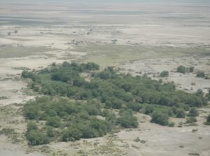 In the case of the land subdivision threat, ACP is assisting ACC in land use planning on Mbirkani Group Ranch, with a view to expanding the planning to other ranches. The land planning process has gone through several iterations since last year and is currently under review by the group ranch membership. Once completed and adopted, the plan will zone the ranch into different uses.
The main use, livestock and wildlife enterprises, will occupy the major portion of the Mbirikani. Under GEF funding, ACC and Big Life will assist the group ranch in preparing grazing practices based on traditional seasonal movement patterns that have broken down for lack of management. Specially trained scouts under Big Life and RAs under ACP/ACC will monitor and enforce grazing practices.
In the case of pasture degradation, ACP wrote up the grant proposal on behalf of AET to secure a Dutch NAGA grant for habitat and pasture restoration. ACP has since assisted KWS and AET in designing and setting up three woodland restoration plots inside the park. It has also helped Ololorashi and Mbirikani Group Ranches establish eight traditional grass banks known as olopololi. The fenced olopololi restore cover on degraded lands adjacent to permanent settlements and are maintained by the community for late season calf grazing. The restoration plots are now complete and will be monitored by the RAs under David Maitumo’s guidance.
In the case of biodiversity loss due to elephant compression, the earlier woodlands plots set up by ACP have been replicated by KWS, Serena, Tortilis Lodge, and in the last year, by the NAGA funded project, making ten in all. GEF funds will add another five or more. In collaboration with AET, ACP has set up a restoration group that will draw up a long-term habitat restoration program for the park and pastoral lands. The recovery of woodlands at the site ACP set up in 2001 has been remarkable.
Camera traps recently recorded lesser kudu in the plot, the first siting in the park since the species disappeared with the loss of woodlands in the 1980s.
man-wildlife conflict, the main tension arises from the growing elephant and lion populations and the expansion of their ranges. The last few years have seen a sharp rise in conflict with farmers and pastoralists. Big Life and other NGOs supporting the Amboseli community scouts have begun turning their attention to the conflict.
In January AET established a HWC group to address the problem following several incidents in which farmers and herders were killed and severely wounded by elephants. The group brings together representatives of the pastoral and farming community, KWS, Big Life, Lion Guardians, IFAW and ACC/ACP to map and anticipate conflicts, draw up preventative and mitigation measures and coordinate action.
ACP will take on the role of setting up the data base and helping plot and anticipate conflict areas. The group held its inaugural meeting in March and will focus first on constructing a 35km high-wire electric fence to protect the shambas in Namalog and Kimana east of Amboseli and the expansive farms on the slopes of Kilimanjaro.
The HWC group covers all species and will prepare a generic template for winning space for large herbivores and carnivores and reducing conflict in the borderlands area through the auspices of Borderland Conservation Initiative.
The future of wildlife lies in collaboration and modern sensibilities
The future of wildlife lies in collaboration and modern sensibilities
 Dr. David (Jonah) Western, Chairman of the African Conservation Centre, Nairobi, Kenya presents a talk at Oregon State University, about why cooperation is the hallmark of our success in eliminating wildlife and converting natural habitats to human use.
What will it take to avert a mass extinction? Lessons from the pastoralists of East Africa and ranchers of the American West show how collaboration and modern sensibilities offer hope for wildlife through coexistence
Northern Tanzania ecosystems monitoring workshop
Northern Tanzania ecosystems monitoring workshop
On April the 5th a mixed team of community resource assessors (RAs) and research staff travelled down to Arusha to provide training on community based ecosystem monitoring.
The training was conducted by staff from the South Rift Association of Landowners (SORALO) and the Amboseli Conservation Program (ACP). The trainees were made up of several NGOs working within the rangelands of Northern Tanzania.
Representatives from Oikos, Northern Tanzanian Rangeland Initiative (NTRI) and Tanzanian People and Wildlife (TPW) attended. One trainee Resource Assessor from Mkuru village was also present, but otherwise the attendees were staff who would supervise and train RAs across the wider landscape.
This training event followed on from the previous training provided by ACC and ACP in August 2015, with more focus on hands on skill for vegetation data collection.
 The training took place over the course of Monday afternoon and Tuesday morning. The main emphasis of the sessions was to give hands on practical advice to those staff that will be responsible for supervising and collecting data in the field.
We covered several different methodologies including the pin-frame (used by SORALO), the height times cover methods (used by ACP), and briefly went over techniques for species composition analysis. The attendees were also introduced to method used for point counts, which collect information that is used for understanding the spatial and temporal changes in wildlife and livestock numbers across the region.
The final session focused on monitoring design, data entry and analysis. We briefly covered the current best practices for monitoring design and set up, looked at the various types of data entry, and the tools being developed by ACP and SORALO to automatically generate indicators and reports based on the field data. Although this session was brief, a good discussion was had, which focused on what was needed to make this information more useful to communities – for better decision making and for land-use planning.
Although this was just the initial stages of discussions, a further workshop is scheduled for the middle of the year, to focus on how we can integrate data at a landscape level, and provide easy and simple tools to produce indicators and outputs for communities and NGOs.
In the coming months several of the Tanzania partners will begin the first steps towards implementing their ecosystem monitoring, with the first ten Tanzanian plots capturing rangeland information over 250 square kilometers.
This data will provide invaluable for the local community, and for the much larger Kenya – Tanzania Borderlands area – where ecological monitoring is rapidly spreading to create a large network of information on the pastoral landscape.
Kenya’s biodiversity atlas launched
Kenya’s biodiversity atlas launched
The Minister of the Environment, Professor Judi Wakhungu, officially launched Kenya’s Natural Capital: A Biodiversity Atlas at a breakfast ceremony in the Crowne Plaza, Nairobi, on 17th of November.
The atlas was commissioned by the Ministry of the environment and produced by a team of government agencies, conservation organizations and academic institutions led by African Conservation Centre’s chairman, David Western and director, Lucy Waruingi.
Here are some excerpts from the opening chapter of the atlas:
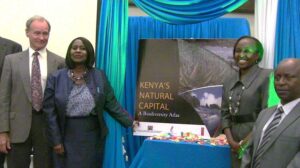 Kenya is known as the safari capital of the world, a place where rhinos, lions and giraffe stroll by tourist vehicles within sight of bustling downtown Nairobi.Less publicized is Kenya’s majestic scenery.
The nation’s rich collage of landscapes range from the Chalbi Desert in the north to the snow clad peaks of Mt. Kenya, from the white beaches of the Indian Ocean to the shores of Lake Victoria, and from the rolling plains of Maasai Mara to the floor of the Great Rift Valley. Kenya is also the foundry of varied cultures and lifestyles rooted in the productivity and diversity of its landscapes.
Over forty ethnic groups spanning hunter-gatherers, herders, farmers, fishermen artisans and traders depended for eons on the providence of the land, soils, waters, plants and animals.
The interactions between topography, soils, hydrology, plants, animals and peoples within each eco-climatic zone create locally distinctive ecosystems, including forests, woodlands, shrub-lands, grasslands, deserts, wetlands, lakes and rivers, montane, afro-alpine and marine ecosystems.
Kenya, ranks among the world’s richest biodiversity nations and hosts over 35 000 species, including more than 7000 plant species and many endemic, rare, endangered and threatened species.
Kenya’s Natural Capital: A Biodiversity Atlas is a national endeavor commissioned by the Ministry of Environment, Water and Natural Resources to document the natural wealth of Kenya. The atlas gives provisional maps of Kenya’s biodiversity. It explains what accounts for the richness of its ecosystems and the survival of its unique mega fauna in the 21st century.
The atlas also looks at the status and threats of Kenya’s biodiversity; the values it affords society; the steps taken to protect it and the challenges ahead. It further points to the need for Kenya to fully value its natural capital and provides a framework and case studies for how to do so.
Finally, the atlas points to a new vision and strategy for how Kenya can incorporate natural capital as one of the pillars of its national development alongside the economic and political pillars on which Vision 2030 is founded. It is intended above all to give Kenyans in all walks of life an atlas that recognizes and values the rich biodiversity of our country and lays the foundation for a sustainable future rooted in conservation and efficient use of natural capital.
At the launch, the African Conservation Centre, in collaboration with the African Centre for Technological Studies, released policy briefs on the use and applications of the atlas for national policy makers, country decision-makers, the business community and learning institutions.
The atlas will be freely available online and continually updated in digital form.
Rains come to Amboseli
Rains come to Amboseli
The rains finally fell heavily in Amboseli on November 17th, flooding the basin in a seven-hour deluge. I had to fly through low cloud and a steady downpour to land at the main strip.
On the ground the pans had filled with water and the wildebeest had vacated the swamps and gathered on the short grass plains. Two days later most wildebeest had migrated north.
I have not seen such a dramatic start to the rains in years. The previous week, the plains were sere and windswept, a few days later puddled with water and sprouting new growth.
Kenya’s Met office had been predicting the imminent onset of torrential El Niño rains since September and the government has raised emergency funds in preparation for the expected floods. The hard times in Amboseli, which I reported in October ACP news, continued into mid-November.
By the time the rains came Maasai cattle were dying and over 7,000 had pushed into the park for forage. I reported that wildlife would get by because of the unexpected spread of the swamps and proliferation of new growth. Despite the delayed rains, adults wildebeest are generally in fair condition, having got a boost from the extensive grass growth at the far end of Longinye Swamp. The newly weaning calves are in far worse condition though.
A few have hides turned white and staring with starvation, similar to the wildebeest dying in the 2009 drought. Their poor condition and dying livestock point to the depleted state of Amboseli pastures. And, once again, the buffalo area grazing deep in the swamp for lack of pasture. I photograph a herd of 87 buffalo grazing up to their bellies in the swamps with infants barely keeping above water.
The pressure on Amboseli speaks to the far bigger threat of rangeland degradation in Eastern Africa and the rising frequency of drought (download article here). However good the El Niño rains, the recovery of the rangeland will be sharply depressed by heavy grazing. The carryover effect spells hard times for pastoralist and their livestock and growing conflict with wildlife.
Collaboration with the University of York, UK
Collaboration with the University of York, UK
Rebecca Kariuki is a PhD student at the University of York, UK researching on the interaction between ecosystems, climate and societies in East African rangelands.
Prior to commencement of her PhD she worked at ACP on plant size structured ecosystems. She joins ACP on 6 months secondment, starting October 2015 to continue working on the size structure of plant in relation to the main variables driving savanna vegetation types in Kenya. Additional details on her research can be found http://www.york.ac.uk/environment/our-staff/rebecca-kariuki/
Amboseli restoration program underway
Amboseli restoration program underway
The restoration of the Amboseli ecosystem following years of habitat loss and pasture degradation took a step forward in the last month with funding from the NAGA Foundation. Under the Global Environmental Facility grant awarded to KWS and partnering organizations to restore and sustain Amboseli’s biodiversity, funds are allocated for recovering woodland habitats in the park.
The GEF grant has, however, been delayed, awaiting the appointment of a new director of KWS. The NAGA grant is timely, not only in setting up woodland restoration plots immediately, but also in expanding the restoration plan to include more woodland sites and address the far more serious problem of rangeland degradation across the ecosystem. The NAGA grant is issued to the Amboseli Ecosystem Trust, supported by ACP, ACC and Kenya Wildlife Service.
The lack of red tape in the NAGA grant allowed us to move quickly in locating three woodlands restoration plots and setting up a number of grassland recovery sites around heavily degraded Maasai settlements.
Two woodland plots span the park boundary and include portions of the adjoining group ranch, where they will protect the Amboseli Ecosystem Trust’s Nongotiak Resource Centre from heavy grazing, and the Kitirua Hills spring from trampling by livestock. In barely a month the sites were selected, the fence designs drawn up, the tenders awarded on a competitive basis and construction underway.
Two of the woodlands plots are now operational in time to benefit from the rains. In showing Carolyn Greene of African Conservation Centre-US the newly complete Kitirua recovery plot, she was fortunate to catch a bull elephant demonstrating his wariness of the fence (see African Conservation Centre-US)
The grassland restoration plots are based on the traditional Maasai olopololi, thorn exclosures located close to settlements to keep out adult stock and reserve a grass bank for calves in the dry season. ACC, working with Maasai women on Mbirikani Group Ranch near Amboseli at the height of the 2009, set up an olopololi that has since restored the grasslands, provided fodder for calves and grown enough seed to sell the surplus (http://www.accafrica.org/).
The olopololi program has the potential to grow rapidly as a Maasai home-grown solution to pasture conservation and management. A similar program has been adopted by the Il Polei and Munushoi communities in the Mukogodo region of Laikipia (http://www.accafrica.org/).
NAGA, in collaboration with AET, ACC and ACP, is also looking into arresting the heavy soil erosion on the Eremito Ridge where permanent settlements have degraded the grasslands and created heavy riling and gullying.
Restoring the wood habitats and grassland of the Amboseli ecosystem will take many years and call for a broad collaborative effort between the Maasai communities, conservation organizations, the Kajiado Council, safari operators, KWS and other government agencies dealing with livestock and water.
On 11th November, the various parties met in Amboseli and agreed to set up a restoration group under the Amboseli Ecosystem Trust to design and oversee a restoration program for the ecosystem. The strongest support came from the Maasai representing the group ranches surrounding Amboseli and spanning the ecosystem.
Amboseli a grand wildlife spectacle again but facing more hard times
Amboseli a grand wildlife spectacle again but facing more hard times
I did another aerial count of the Amboseli National Park and basin on 29th September and was thrilled to see so many animals around the swamps, the most I have seen since before the drought of 2009. Buffalo numbers are now above 300, half way to their pre-drought level. Zebra and wildebeest numbers are recovering somewhat faster and are two thirds back to their pre-drought numbers.
Though still far short of full recovery, the tightly concentrated herds around the permanent swamps in the late dry season make Amboseli one of the greatest wildlife spectacles in Africa.
Despite the recovery so far, the longer term outlook for Amboseli’s wildlife is far from secure. I only counted 358 elephants, down sharply from earlier in the season. With some 1,300 elephants dispersed out of the park and farmers and herders facing a harsh season, conflict has become the biggest hurdle to conserving elephants in Amboseli.
The falling numbers in the park reflect their heavy grazing impact on the swamps. The sedges have been grazed down all along Simek and over most of Longinye Swamp. Open water and green weeds now dominate the wetlands. The open water is still expanding and has pushed fresh floods northwards alongside the Namanga Road.
On the downside, I counted nearly 7,000 cattle and over 1,000 sheep and goats in the park, the biggest influx in many years. Several herds had pushed into the middle of Longinye swamp, others were scattered across Kalunyet and large herds were watering in the park. The long rains in southern Kenya were below average and the weak rebound due to heavy grazing has created an acute shortage of pasture.
Tens of thousands of cattle, sheep and goats have pushed deep into Tsavo West National Park and the Chyulus Hills.
The pressure on Amboseli will continue to mount even with good rains. The influx of livestock has rapidly depleted the abundant grass reserves at the start of the dry season. If not for the flooding and new growth in the swamps, this season would be harsh for zebra and wildebeest too.
I anticipate that with livestock numbers fully recovered from the 2009 drought due in part to animals purchased and imported from elsewhere, the pressure on Amboseli will thwart a full wildlife recovery and raise the specter of another drought. The reasons why, are explained in the following news section on the growing causes of drought in Amboseli.
Amboseli study highlights growing causes of drought and land degradation
Amboseli study highlights growing causes of drought and land degradation
Pastoralists across the East African savannas are reporting more frequent and deeper droughts, leading to social disruption, growing poverty and deepening conflict with wildlife. Climate change has widely been cited as the cause of worsening droughts.
Is there evidence to support the rising incidence of drought, and if so, what are the causes and remedies?
Drought predictions and early warning systems depend largely on indirect measures based on satellite tracking of green vegetation and rainfall measures and predictions. Neither method has been tested against long term measurements of actual pasture abundance, or the severity of droughts for livestock and wildlife. How well do these drought predictions perform?
Twenty grassland plots in Amboseli measured each month by ACP since 1975 provide a good test of the accuracy of drought predictions. A study, published in PLoS ONE (download here) in August 28 2015 by David Western, Victor Mose and David Maitumo, concludes that neither satellite imagery nor rainfall measures satisfactorily predict extreme droughts. The grazing pressure by livestock and wildlife is far more important in dictating the shortage of forage and severity of droughts.
The study also shows that pasture shortfalls are increasing in frequency and intensity due to grazing pressure have risen nearly three-fold in the past 35 years. Although rainfall has not fallen significantly, grass production per unit of rainfall has fallen by a third, causing a sharp drop in livestock and wildlife production. The causes are explained by the loss of grazing lands to farms, water diversion and permanent settlement leading to the year-round grazing of pastures.
We conclude that the remedies largely lie with herders through better rangeland governance, herding practices based on traditional migratory movements, and grazing rotation (see Better grazing practices hold key to Kenya drought. SciDev.Net. 5 August 2011). Collaborative grazing practices and land use planning are now the focus of ACC’s conservation work with group ranches in Amboseli and the South Rift.
Just as important, the Amboseli study shows that regular rangeland monitoring such as David Maitumo conducts in Amboseli each month can be conducted simply and rapidly by community resource assessors using simple methods. The information feeds back directly to herding committees, allowing them to take stock of pasture conditions, anticipate extreme droughts and plan their responses
Launch of Collaborative Natural Resource Management booklet
Launch of Collaborative Natural Resource Management booklet
The booklet on Community-Based Natural Resource Management: Creating an Enabling Policy Environment in Kenya was launched by the Cabinet Secretary for the Environment, Professor Judi Wakhungu, at a colorful ceremony at the Lale’enok Resource Centre in the South Rift on 11th October 2015 .
The booklet (see Library) summarizes the findings of a meeting of Southern and Eastern African countries held in December 2013. The meeting drew on 30 years of African experience in Collaborative Natural Resource Management to highlight successful practices and chart the way forward for a Community Bases Natural Resource Management (CBNRM) policy for Kenya.
 Commissioned by the Ministry of the Environment, funded by NORAD through WWF and by the Liz Claiborne Art Ortenberg Foundation, the meeting was organized by ACC and ACP.
The meeting of African practitioners and scholars concluded that CBNRM, based on traditional practices and community-based conservation in Africa, is fast becoming a worldwide practice.
The Lale’enok Community Resource Centre was chosen as the launch site of the booklet to highlight the steps communities have taken to conserve and manage their own resources (www.soralo.org).
The meeting was attended by the Deputy Governor of Kajiado, Paul Ntiati, senior representatives of the Kenya Forest Service and Kenya Wildlife Service, political leaders, community leaders and a large gathering from the local community.
Biodiversity informatics conference (TDWG 2015)
Biodiversity informatics conference (TDWG 2015)
ACC hosted the annual international Biodiversity Informatics (TDWG) Congress at the Windsor Golf Hotel in Nairobi between September 28th and October 1st.
 The meeting highlighted advances in biodiversity informatics tools and the integration and application of large databases for biodiversity conservation and community development. Lucy Waruingi, Director of ACC and David Western, Director of ACP, gave a keynote address on Building biodiversity knowledge from the ground up: Tools and approaches at a local, regional and national level, applied in Kenya to document and understand Kenya’s biodiversity.
Dr. Victor Mose, Deputy Director of ACP also hosted a special session on the use of camera traps and other tools for conservation. Information on the conference and talk can be found here
Amboseli wildlife makes a comeback
Amboseli wildlife makes a comeback
I flew an aerial count of the Amboseli basin on 30th July and did a ground survey with David Maitumo and Victor Mose on 14th August. The increase in wildlife in the last few months was astonishing. The herds are rapidly rebuilding to their pre-drought levels after being held down by predators in the years since the devastating losses of 2008. I counted some 330 buffalo, up from 160 after the drought and halfway back to the 600 level of 2009.
The zebra population is continuing to climb steadily and wildebeest numbers have jumped since earlier this year. I suspect the increase is in part due to an influx from Tsavo or Tanzania this dry season.
The biggest surprise to me was the number of hippos. Once few and illusive, groups of ten or more are visible all along two large swamps and out on the banks sunning to the delight of park visitors.
The highest number I’ve counted, around 100, was shortly before the 2008 drought when over 30 hippos died of starvation. Although I didn’t do a full count, I put their numbers now at 200. So what accounts for their increase?
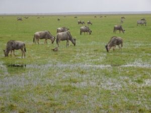
The most likely reason is the rich matt of grasses that have sprung up across the swamps after the elephants chomped down the tall sedges.
I watched a group of seven hippos half submerged in the swamp snatching at dense wads of forage in the middle of the day without having to budge.
Amboseli habitats to be restored
Amboseli habitats to be restored
ACP teamed up with the Amboseli Ecosystem Trust, Kenya Wildlife Service, the African Conservation Centre and Big Life in winning support from the NAGA Foundation to restore fever tree and tortilis woodland in and around Amboseli National Park damaged by many years of heavy elephant concentration.
The program will also restore pastures damaged around permanent livestock settlements by setting a series of traditional olopololi, calf grazing areas protected by thorn fencing.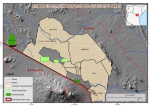
The start-up funding in the first year will cover the cost of setting up and monitoring three high-level electric fences that exclude only elephants, allowing seedlings held in check by heavy browsing to mature and regenerate the once abundant woodlands of Amboseli. More details of the restoration program will be posted shortly.

Kenya’s rangelands at a crossroad. ACP co-hosts the first Annual Rangeland Congress of Kenya
Kenya’s rangelands at a crossroad. ACP co-hosts the first Annual Rangeland Congress of Kenya
1st Annual Rangeland Congress of Kenya: 11th and 12th August 2015
The future of rangelands is at a crossroad. Covering three quarters of Kenya, supporting 60 percent of national livestock herd and 90 percent of all wildlife, the rangelands face grave threats. The threats include population growth, poverty, land degradation, recurrent drought, loss of rivers and wetlands, declining wildlife and climate change. The collapse of subsistence economies and cultures has left families destitute.
Land subdivision and sales, the extraction of charcoal, sand, building stone and wildlife poaching have risen with poverty and social disruption. Poor social services and lack of technical skills hamper opportunities for alternative livelihoods in a tight job market.
Despite the enormous threats facing Kenya’s rangelands, the opportunities to reverse the trends through improved breeds, better husbandry and marketing skills, range restoration, grass banks, arable and irrigated arming, wildlife enterprises, ecotourism, renewable energy, carbon markets and natural resource businesses have been poorly developed.
The 2010 constitution sets the tone for rangeland communities to form a strong constituency, set the agenda and build the skills needed to conserve and develop the arid and semi-arid lands.
Many progressive landowner associations have taken the initiative in recent years to redress the threats and open up new opportunities for managing and sustaining the rangelands.
The Rangelands Association of Kenya, in collaboration with the African Conservation Centre, University of Nairobi Centre for Sustainable Dry lands Ecosystems and Societies and the International Livestock and Research Organization, hosted the congress at the Commercial Bank of Africa Conference Centre in Nairobi on the 11th and 12th of August 2015. The congress brought together the voices and views of land owner associations invited speakers, government and country governments, national and international agencies to highlight the status, threats and opportunities in the rangelands and chart the way ahead.
David Western and Lucy Waruingi of African Conservation Centre were key speakers. Courtney White, founder of the Quivira Coalition based in New Mexico, gave a talk on the New Ranch concept emerging in the US to ensure sustainable and resilient ranching practices and restore degraded rangelands.
After the congress members of the Rangeland Association of Kenya held a one-day meeting to decide on the way ahead. The steps will include recruiting as many rangeland communities and associations as possible in the coming year to give them a strong voice in the conservation and management of their lands; address the marginalization of pastoral societies; engage national and county governments on policy and planning matters, build up the management capacity of communities in collaboration with NGOs, improve access to education and information; promote sustainable livestock systems and wildlife conservation enterprises, and draw on the best of traditional and modern husbandry practices in guiding the transition from subsistence to market economies.
At the closing of the congress David Western formally launched the Rangeland Association of Kenya, representing landowner associations. Prof. Jessi Njoka of University of Nairobi announced the launch of the Rangeland Society of Kenya, representing professional managers and scientists.
Northern Tanzania Ecosystems Monitoring Workshop
Northern Tanzania Ecosystems Monitoring Workshop
Mbirikani Group Ranch 14th to 16th August 2015
The workshop brought together conservation organizations interested in setting up ecosystem monitoring practices in northern Tanzania under the umbrella of the Borderlands Conservation Initiative (BCI) and the Northern Tanzania Rangeland Initiative (NTRI).
The two-day training workshop included participants from HoneyGuide (HG), Wildlife Conservation Society (WCS), Tanzania People and Wildlife (TPW) and Progetto Oikos. The Uaso Nyiro Baboon Project in Kenya also attended.
The workshop was conducted by David Western, Victor Mose and David Maitumo of the Amboseli Conservation Program (ACP) and the African Conservation Centre (ACC), with support from the Amboseli Resource Assessors (RA’s), Paul Kasaine, Samuel Lekanaiya and George Sunte.
The workshop covered the monitoring techniques developed and conducted in the Amboseli ecosystem over many years. The workshop was designed for heads of programs and those overseeing the monitoring. Training for community-based RAs will be given on the ground, preferably in Tanzania, once candidates have been appointed.

An introduction to the long-term monitoring Amboseli program was given on site in Amboseli on 14th August ahead of the workshop. The workshop, held at Big Life on Mbirikani Group Ranch, took place on 15th and 16th August, demonstrated all aspects of monitoring design, methodology, field equipment, data storage, and applications to range-land conservation and management.
The workshop began with a demonstration of how to measure a range-land plots and code, record, enter and process data using open source software to produce rapid statistical and visual outputs for immediate application.
The workshop covered the following aspects, including designing and setting up an ecological monitoring scheme, sampling
design, tools, and communicating the findings to decision-makers and on websites.
The role of RAs and their value in collecting and providing information to their communities has grown steadily in recent years and includes, natural resource mapping; land use surveys; testing and assessing the impact of development and restoration programs; socioeconomic and attitudinal surveys, and Information communication and outreach.
SETTING UP AND INTEGRATING MONITORING PROGRAMS
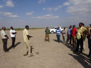
The final session discussed how to set up, fund, integrate and coordinate rangeland monitoring among the participating partners in northern Tanzania between partnering organizations in Kenya.
It drew heavily on the organizational approach for coordinating research, planning and management adopted by the Amboseli Ecosystem Trust. HG, Oikos, TPW and WCS have submitted a proposal to US AID under the umbrella of NTRI to set up monitoring programs in northern Tanzania.
The organizations present agreed to link up monitoring projects southern Kenya and northern Tanzania through BCI’s community-driven program. Subject to funding availability, ACP will set up a Windows-based platform that includes databases and analytical packages based on open-source software.
The workshop concluded with an agreement to work towards a common website that would provide a monthly assessment of range conditions across the borderlands region and early-warnings of pasture shortfalls and hard times for wildlife and livestock.
David Muiruri of the Uaso Nyiro Baboon Projects attended as an observer and Howard Fredrick of the Tanzania Conservation Resource Centre joined the field program in Amboseli.
African Conservation Centre founder, Dr. David Western, is a nominee for the world’s biggest conservation award, the 2016 Indianapolis Prize
African Conservation Centre founder, Dr. David Western, is a nominee for the world’s biggest conservation award, the 2016 Indianapolis Prize
The African Conservation Centre is pleased to announce that our founding executive director, Dr. David Western, is a nominee for the 2016 Indianapolis Prize. Initiated in 2005 by the Indianapolis Zoo, this prize is recognized as the world’s leading award for animal conservation.
The Indianapolis Prize is awarded biennially to an individual who has made extraordinary contributions to conservation efforts involving an animal species or group of species. In addition to a $250,000 cash award, the winner — selected from among six finalists — receives the Lilly Medal and each of the other five finalists receives $10,000.
Finalists will be honored at the next Indianapolis Prize Gala to be held Oct. 15, 2016.
Dr. Western was selected as a nominee for his more than 48 years of pioneering research and community-based conservation strategies in East Africa. He was among the first scientists to recognize the limitations of national parks and investigate how humans and wildlife can coexist.
His pioneering community-based conservation work has served as a model for finding a place for wildlife beyond parks around the world. As former executive director and current chairman of African Conservation Centre, director of Kenya Wildlife Service and conservation director for Wildlife Conservation Society International, Western has been a leader in many areas of conservation, including research, international programs, short and long-term conservation planning, ecotourism, training, directing governmental and non-governmental organizations and public education.
He established the Wildlife Planning Unit in Kenya in 1978, was the chairman of the African Elephant and Rhino Specialist Group in the 1980s, founding president of the International Ecotourism Society, chairman of the Wildlife Clubs of Kenya and Carter Chair of Conservation Biology, Wildlife Conservation Society.
He established the “Parks Beyond Parks” movement to promote communities setting up their own wildlife sanctuaries and enterprises and led efforts to set up the first community-based wildlife conservancies in Kenya. Western also promoted horizontal learning exchanges in East Africa and around the world so that communities can learn first-hand from each other’s experience.
During his many national and international assignments, Western has continued his groundbreaking research in Amboseli. The Amboseli Conservation Program he set up in 1967 is the longest running ecosystem research program in Africa.
His research has pioneered the integration of human-wildlife studies, underscored the significance of pastoralism in savanna ecosystems, shown the underlying basis of human-wildlife coexistence in the savannas and developed many of the basic techniques for studying and monitoring large mammal ecosystems.
His research into the life history and ecology of large mammals has been cited as one of the foundational studies in the new field of macroecology. His articles have appeared in Science, Nature, Proceedings of the National Academy of Science, Bioscience, PLoS, Ecology and other prominent science journals.
His honors include the World Ecology Award, Harris World Ecology Center at the University of Missouri-St. Louis; Conservation Medal, Zoological Society of San Diego; Lifetime Achievement Award by the International Ecotourism Society; Order of the Golden Ark; San Diego Zoo Conservation Medal, Cincinnati Zoological Society; and Elder of the Burning Spear.
Western’s publications include Conservation for the Twenty-first Century (OUP, 1989), Natural Connections: Perspectives in Community-based Conservation (Island Press, 1994) and In the Dust of Kilimanjaro (Shearwater, 2001). He earned his bachelor’s degree from Leicester University in England and his doctorate from the University of Nairobi in Kenya. Leicester University awarded him a prestigious “Doctor of Science” in 2002.
For more information about the Indianapolis Prize, please visit: www.indianapolisprize.org
Amboseli Community-Based Conservation Highlighted at the World Parks Congress
Amboseli Community-Based Conservation Highlighted at the World Parks Congress
At a special session of the World Parks Congress held in Sydney, Australia, in November 2014, David Western gave a presentation on the role of community-based conservation in winning space for wildlife beyond national parks and in reducing human-wildlife conflict.
Amboseli played an important role in gaining recognition for community-based conservation as a complement to national parks when David Western gave a presentation at the World Parks Congress in Bali in 1982. The first of its kind in Kenya, the initiative launched in Amboseli in the early 1970s led to a new nation policy aimed at ecosystem-wide conservation through the engagement and to the benefit of local communities.
Amboseli has since been a test-bed for new conservation policies and practices that have become widespread throughout Kenya and internationally. The most recent advances are the adoption of the Amboseli Ecosystem Management Plan following the completion of a Strategic Environmental (SEA) commissioned by the National Environmental Management Authority. The SEA approval makes the Amboseli ecosystem plan to first of its kind to be given legal recognition and enforcement through the higher national authority.
A full account (Finding space for wildlife beyond parks through community-based conservation: the Kenya experience) of the role Amboseli has played in developing and promoting community-based conservation and the success of the movement over the last forty years can be downloaded here.
Another First for Amboseli: Legalization of the Ecosystem Plan
Another First for Amboseli: Legalization of the Ecosystem Plan
The Amboseli Ecosystem Management Plan 2008-2018 ran up against developers bent on yet more lodges and residential estates around the over-crowded eastern border of the national park. Appalled at the prospect of urban sprawl at the gateway to the park, hoteliers and conservation bodies asked the Amboseli Ecosystem Trust to press for gazettement of the plan.
AET called on the National Environmental Management Agency (NEMA), which called together the parties concerned in 2013. All parties unanimously agreed on a year-long moratorium on any further development, pending the completion of a Strategic Environmental Assessment (SEA).
AET hired consultants to conduct the assessment with $100,000 donated by the conservation organizations, including ACP and ACC. The assessment was completed late in 2014. NEMA has since authorized the legal gazettement of the Amboseli Ecosystem Management plan, overseen by AET.
The legal provisions for the Amboseli ecosystem plan is the first of its kind. The plan zones and limits developments to ensure that the seasonal movements of wildlife and livestock remain unimpaired.
Good News for Elephants
Good News for Elephants
Over 30,000 elephants were poached across Africa in 2013, driven by the sky-rocketing price of ivory and illegal trafficking. Kenya was cited by the Convention on International Trade in Endangered Species as a major conduit for the export of ivory.
Over the last year Kenya Wildlife Service has been lambasted in the press and by watchdog conservation bodies for covering up a poaching crisis in Kenya. KWS countered that poaching fell in 2014: poaching is under control following a concerted effort by government forces.
At the urging of ACP in the Ministry of the Environment, KWS convened a National Elephant Conference on 19th and 20th February to take stock of the status of elephants.
A summary of the continental picture by the African Elephant Specialist Group showed that poaching posed a grave threat to the species, especially in West, Central Africa and much of Eastern Africa. In contrast, elephant populations remained stable in Southern Africa.
Kenya showed a decrease in poaching in 2014. The findings were supported by detailed locational analysis by KWS and Iain Douglas-Hamilton of Save the Elephants. The number of poached elephants as a proportion of all animals dying fell below critical levels in most populations, with the notable exception of Maasai Mara.
Though the decline in poaching is good news, the status of Kenya’s elephants overall is clouded by uncertainties over numbers in forested parks, including Abedares and Mount Kenya. Forest parks, which account for twenty percent or more of the Kenya’s elephant population, have not been counted in years.
The best news came from Amboseli. Here poaching levels remain negligible—only one for certain, perhaps three in 2014, all on the periphery of their range. Numbers have reached 1,500 and are still growing after recovering 2009 drought losses. The population is also expanding its range, making Amboseli one of the safest locations in eastern and central Africa.
Amboseli’s success in protecting elephants stems in large measure from the engagement of the Maasai community in conservation dating back to the mid-1970s. At the KWS conference David Western reviewed the history of the Amboseli elephant population based on his long-term monitoring work starting in 1967.
He showed that ivory poaching killed off half the elephants in less than five years in the early 1970s. Poaching stopped abruptly once the community began benefiting from parks revenues, this despite the continuing losses to poachers throughout Kenya until the world-wide ivory ban of 1990. By then, the Amboseli elephants had recovered to their pre-poaching levels.
The recent success of elephant conservation in Amboseli is due to KWS field forces, organizations such as Big Life, Amboseli Trust, ACC and other NGOs funding the network of some 300 community scouts, and the backing of the Maasai community.
The lessons from Amboseli and need for a broad collaborative approach to conserving elephants in the Kenya-Tanzania borderlands was presented at the Kenya National Elephant Workshop at Kenya Wildlife Service, Nairobi.
Kenya National Elephant Workshop, Kenya Wildlife Service February 18th and 19th 2015
Kenya National Elephant Workshop, Kenya Wildlife Service February 18th and 19th 2015
A collaborative approach to conserving large free-ranging elephant populations in the Kenya-Tanzania borderlands
David Western and Peadar Brehony
Borderlands Conservation Initiative & African Conservation Centre
ABSTRACT
The escalating price of ivory on the international market in the last few years threatens the survival of elephant herds across Africa. The threats are as great now as the 1970s and 1980s when a surge in ivory prices plunged Kenya’s elephant population from 160,000 to 19,000 and rhino numbers from 20,000 to 350.
The remaining herds retreated to national parks and reserves where they took a heavy toll on woody vegetation and biodiversity. Despite the threats being as grave, Kenya’s commitment and capacity to protect its elephants is far greater now than the 1980s due to wide public support for conservation, the superior anti-poaching forces of KWS, better scientific methods for tracking and protecting herds and more funding.
Above all, there is now the commitment and capacity of communities to conserve wildlife and deters poachers where they once moved freely. If, but only if this capacity is mobilized through close collaboration between governments, communities and NGOs, elephants living outside as well as within protected areas can be kept safe.
And protecting all of Kenya 37,000 elephants is vital, given that two thirds reside outside parks where they are an economic asset to the 140 private and community conservancies countrywide.
We look at how the largest free-ranging population in eastern Africa, the 25,000 or so elephants spread along Kenya-Tanzania borderlands from Serengeti-Mara to Tsavo-Mkomazi, is being conserved by collaborative efforts under the Borderlands Conservation Initiative.
In 2012 BCI brought together government agencies, communities and NGOs spanning the 120,000 square kilometer and 16 parks and reserves to map and monitor elephants movements. The combined effort has produced a comprehensive map of elephant distribution and movements, trained and deployed scouts to vulnerable areas and brought down poaching.
The scouts also protect lions and other species and help avert and reduce human-wildlife conflict. BCI will also produce elephant suitability maps for sustaining the free-ranging elephant herds connecting parks and community wildlife areas across the borderlands.
Elephant-Human Conflict: A Growing Threat
Elephant-Human Conflict: A Growing Threat
The rising numbers and spreading herds of elephants in Amboseli is a conservation success, but fast posing a new problem to people and small farms (shambas). In the last few months elephants have killed four people and destroyed millions dozens of shambas.
One community blocked the Loitokitok Road until KWS took action on an elephant that killed a local resident. The Assistant Director Southern, Julius Cheptei, called a meeting of conservation organizations and government agencies at Serena Lodge on 24th February to address the conflict.
He expressed his concern that community support for elephants would wane if the conflict is not addressed promptly. He wants Amboseli to have the first human-elephant conflict plan in Kenya and to move quickly.
David Western gave a backdrop to the history of elephants and people in Amboseli at the opening of the meeting. He noted that after the world-wide ivory ban of 1990, human-elephant conflict had risen steeply around Kenya as elephant numbers rose, herds spread and lost their fear of people.
KWS took firm measures to contain the conflict. Quelling the conflict in Amboseli calls for a collaboration between KWS, NGOs and communities under the umbrella of the Amboseli Ecosystem Trust. Success hinges on mapping and tracking elephant movements, anticipating high conflict areas, and taking early action to prevent threats to people and property.
Craig Miller of Big Life gae an update on human-elephant conflict. There were over 553 crop-raiding incidents in 2014 at an estimated cost of Ksh 43 million, nearly half a million dollars. He estimated that only a third of all cases were reported.
Most farmers don’t bother reporting incidents, given the time involved and lack of response. Conflict was now a far bigger threat to elephants and people than poaching. Noah Sitati of African Wildlife Foundation gave a comprehensive presentation on the many ways to address elephant conflict.
The meeting concluded that a two phase plan is needed, the first a rapid response to the current conflict, the second a longer term strategic plan to avoid conflict though spatial planning and aversive measures.
The first steps will set up a common database to map and anticipate elephant movements, identifying conflict hotspots and train up extra rangers and scouts to contain conflict and forewarn and prepare communities.
World Parks Congress
World Parks Congress
David Western and former director of ACC, John Waithaka, attended the World Parks Congress in Sydney in November 2014 to address a special session on human-wildlife conflict.
Together with John Kamanga of the South Rift Association of Landowners they gave a talk on Finding Space for Wildlife Beyond National Parks and Reducing Conflict Through Community-Based Conservation: the Kenya Experience.
The looked at the progress in community-based conservation since Amboseli was selected as a pioneering endeavor presented at the World Parks Congress in 1982. The article appears in the March issue of Parks magazine
Studying changes in the Amboseli ecosystem through the eyes of the Maasai
Studying changes in the Amboseli ecosystem through the eyes of the Maasai

Amboseli ecosystem is typical of the dry range-lands inhabited by Maasai pastoralist and rich wildlife herds.
Like range-lands throughout Kenya, Amboseli has seen many changes to the land and in the lives of the Maasai over the last fifty years.
Families with their livestock moved with the seasons, following the wildlife herds on migrations across open lands. Few children went to school and most families lived off their herds and never visited a town. The land was more wooded, with scattered swamps that saw livestock and wildlife through the worst droughts.
Today most children go to school, families have settled in villages, many have taken up farming and new lives and livelihoods no longer dependent on their herds. Much of the woodlands and swamps have been converted to farms, and livestock and wildlife herds have become more restricted in their movements.
As a result, the pressure on the land has increased and livestock and wildlife herds have fallen and face more frequent droughts.The Amboseli Conservation Program has documented these many changes since the 1960s.
But how do the Maasai see the changes? What do they think caused the changes? How are they affected by them, and what can they do to ensure they are in control of the changes? These are some of the questions ACP has asked me to look into as a field researcher and in the course of my M. Sc. thesis.
The field study took three weeks in January and February, assisted by David Maitumo and ACC Resource.
Assessors Paul Kasaine, Samuel Lekanaya, and George Sunte. We conducted questionnaire surveys with many individuals and held group discussions with informants in several locations around Amboseli, some on lands subdivided and privatized (Kimana), some in areas where herders still moved seasonally (Eselengei), and some in areas where pastoralists have settled semi-permanently but still move from time to time (Olgulului).
The two approaches to gathering views of change helped us cross-check observations and assess differences in views. We also asked respondents to map resource patches in the ecosystem, assess their value, judge their status and give their views on changes over the last forty years: before the park was established; post-park; as a result of land subdivision and settlement, and following the harsh drought of 2009.
We experienced a number of challenges, including drought, which made it hard to locate herders who had moved, others too busy or stressed to spend time on interviews, and yet others reluctance to participate because they had received no feedback from previous researchers who interviewed them.
Despite the problems, we sampled 336 individuals out of the 364 we hoped for. Even before analyzing the results, it is clear that the biggest changes seen by the Maasai include decreased dry season grazing areas, reduced household livestock holdings and more frequent droughts.
For many the greatest concerns are loss of land productivity, poor governance over the range resources, lack of proper land use plans and loss of traditional institutions. These changes have decreased the viability of pastoralism.
The results of the study should be complete in three months and will be used in conducting surveys in Kenya and Tanzania on environmental vulnerability of pastoralists, a study ACC is undertaking on behalf of the African Wildlife Leadership Foundation.
Report by: Sakimba Kimiti, Research Assistant
d.sakimber@yahoo.com
Wildlife finally in recovery after the 2009 drought
Wildlife finally in recovery after the 2009 drought
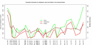 The news on the wildlife front is finally positive after the population crashes of the 2009 drought.
The recovery is captured simply and compellingly by the ACP ground monitoring program: Zebra numbers have sprung back to a pre-drought levels of 6,000 animals. The rebound is due in part to recruitment, but also to fresh immigration from outside the Amboseli ecosystem.
Wildebeest numbers have inched up to nearly 3,000, entirely due to recruitment. Buffalo numbers, which were declining steadily until the long rains, have risen strongly from around 160 to over 280 since then.
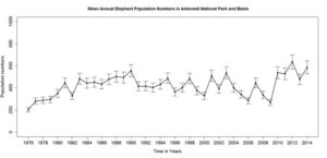 There is clear evidence that at least two herds moved into the basin, most probably from the Kilimanjaro forest. Infant survival is also picking up from heavy predation by hyenas in the aftermath of the drought.
I attribute the resurgence in the ungulate herds of Amboseli in the last year to the strong aversive movement zebra, wildebeest and buffalo have used to escape predation by moving out of the park at night and wide dispersal at the onset of the rains.
Tellingly, now that their numbers are up, the nightly migration of zebra and wildebeest out of the park has ebbed.
Elephant numbers are also continuing to climb and now stand at around 1,600, in the larger Amboseli Ecosystem marking a full recovery from the 2009 drought losses www.elephanttrust.org. The recovery testifies to the negligible poaching, as documented in Big Life www.biglife.org.
The growing Amboseli population is dispersing widely across the Kenya Tanzania borderlands, according to collared elephant tracking by IFAW www.ifaw.org. As reported earlier, elephant numbers in the park grew sharply after a long declined from the late 1980s to the drought of 2009.
The resurgence was due to the lower elephant pressure on the swamps and regrowth of sedges following the loss of some 400 animals in the drought. The elephant numbers in the park have begun to decline once more with the heavy pressure on swamp grazing. The growing and dispersing herds of elephants is causing conflict with farmers east and south of Amboseli.
David Western and Peadar Brehony (coordinator of the Borderlands Conservation Initiative) met Richard Bonham and his staff of Big Life on Mbirikani Group to discuss how to address the mounting human-elephant conflict. We agreed to pull together all the main NGOs, including ACC, ACP and the Amboseli Trust for Elephants to address the conflict under the umbrella of the Amboseli Ecosystem Trust.
The AET board of trustees met the following week and agreed to serve as the umbrella for the human-wildlife conflict study and management program.
Livestock populations
Livestock populations sprang back to pre-drought levels far faster than from natural recruitment. The resurgent population is due in large measure to pastoralists selling their healthy cattle and buying up twice the number of Somali cattle from the north.
The rapid recovery has stunted pasture regeneration and pushed Amboseli back into a premature grazing deficit. Cattle have moved in from as far as the rift valley, putting yet more pressure on the grasslands.
This recurrent boom and bust cycle of livestock and grassland production will be the focal point of land use and herd management at the Mbirikani land planning workshop in January. Funds are available under the GEF grant, starting January, to develop better herd and pasture management programs.
Gazettement of the Amboseli Ecosystem Management Plan
Gazettement of the Amboseli Ecosystem Management Plan
Following the year-long moratorium on developments NEMA (National Environmental Authority) issued pending a Strategic Environmental Assessment (SEA) of the Amboseli Ecosystem Management Plan (AEMP), Amboseli Ecosystem Trust (AET) raised the $100,000 from the NGOs and KWS to conduct the review.
LCAOF has been kept abreast of progress in previous reports. Following a very professional and participatory process, the Strategic Environmental Assessment was approved by the steering committee in November.
NEMA subsequently issued a letter of authorization granting AET authorization over the plan. The gazette binds all government agencies, land owners and developers to the provisions of AEMP. The plan zones the Amboseli ecosystem according to best land uses and tourism intensity zones.
It also calls for a clear demarcation of wildlife dispersal areas and corridors. The SEA of an ecosystem management plan is the first of its kind for Kenya and possibly Africa. It is a landmark in granting the landowner association the responsibility for implementation oversight and integrated natural resource management of the ecosystem. It also calls for livestock and water plans to be drawn up in the coming year.
There has been enormous interest in the SEA process from other landowner association, NGOs and most recently the US Ambassador. He paid a visit to Amboseli in October to review the plans and discuss US funding for similar initiatives.
The gazetted land use plan comes at a time when a new grant from the Global Environmental Facility, administered through KWS, will inject four years of funding into biodiversity conservation and habitat restoration of the Amboseli ecosystem.ACC will also help set up the Nongotiak Resource Centre under contract to AET over the next five years, as it does with Lale’enok under SORALO. Finally, under the Global Environmental Facility (GEF) grant (see below), ACC is provided funds to help build up the capacity of AET. In doing so it will draw heavily on the skills of KWS and other NGOs.
Land use planning in Kajiado County
The governor of Kajiado County, David Nkedianye, who holds a PhD in conservation biology, called on ACP and ACC to co-host a workshop on land planning for the county. The governor is fully aware of the pressures of subdivision and land buying companies poised to snap up pastoral lands for speculative resale to small holders.
We held the meeting in October for a spectrum of leaders across the county to look at the risks of subdivision and promote land use planning. The upshot was that Maasai leaders convened a meeting in Mombasa early November to consider the risks of subdivision. They came out strongly opposed to sub-division ranches until the alternatives have been fully weighed and land use plans drawn up. Kimana Group Ranch adjacent to Amboseli was cited as the prima fascia case against subdivision.
Since the subdivision the ranch has been largely fenced and sold to land speculators, leaving the Maasai with no grazing or future on the land.Following the leaders caution, the Mbirikani group ranch committee has called on ACC to help convene a land use planning workshop in January.
The plans will draw on GEF and other funds to implement the program. Ololorashi Ogului is expected to follow a similar process shortly.
Long-term spatial changes in Amboseli
Long-term spatial changes in Amboseli

The spatial contraction of the Amboseli ecosystem is worrying, based on an analysis of the long-term counts dating back to 1973.
Victor Mose, who attended a special workshop on spatial modeling in ecology held in Birmingham UK in June (watch video below), has been developing visualization tools to distill and illustrate the extent of spatial change in species distributions. The provisional maps (Figure 1) are based on six key species.
The results illustrate a strong contraction in the spatial spread and richness of species in the four main clusters of wildlife populations identified by spatial clustering techniques.
Regaining the spatial connections is important for the health and richness of the ungulate and carnivore populations will be the focus of land use plans ACP will draw up with AET in the coming few months.
ACP staff news, 2014
ACP staff news, 2014
It has been a busy and productive time for ACP and, in the interests of space, only the highlights are covered here.
¨ Funded by African Wildlife Foundation through a Dutch grant, ACP is assisting ACC to draw up an environmental vulnerability framework for northern Tanzania and southern Kenya. The analysis will draw on the long-term data for Amboseli to look at the causes of degradation and biodiversity loss.
¨ Dr. David Western was approached last year by John Galaty, well known for his work on East African pastoralists, to submit a joint grant proposal to the Canadian Social Sciences and Humanities Research Council and IDRC to study and influence community-based conservation in the Tanzania-Kenya borderlands. The two institutional bodies are McGill University and ACC. SSHRC and IDRC awarded eight grants at a launch of the joint funding program in Ottawa in early October.
¨ ACC and McGill University were awarded a seven year grant of $2.5 million. The grant covers studies and training as well as regular reviews of the finding and applications. The study will use changes in wildlife numbers and elephants and lions as keystone indicators, drawing heavily on the outputs of work of the Borderlands Conservation Initiative.
¨ Dr. Victor Mose has excelled in setting up a fully integrated database for Amboseli, overseeing the data analysis and designing open source analytical and visualization tools. He attended a spatial ecology workshop in Birmingham, UK in June and has also attended modeling workshops in Lyon France. He recently presented a paper at the annual bioinformatics (TDWG) congress in Sweden. In addition, he sets up databases and press-button analytical programs for ACC, SORALO and other organizations.
¨ Rebecca Kariuki, who began as an intern with ACP two years ago, has won a prestigious EU scholarship to do her PhD at University of York, working on plant dynamics drawn from the long-term Amboseli database.
¨ Eric Ochwang’i was awarded a Masters in social statistics from the University of Nairobi, based on his analysis of cascade effects caused by the compression of elephants in Amboseli National Park.
¨ Kennedy Sakimber, David Maitumo’s son, has joined ACP and is underway on his Masters looking into Maasai views of change in Amboseli, the causes of change, and how the community is affected and responds.
¨ Dr. David Western attended the World Parks Congress in Sydney in November to give a presentation at a special session of human wildlife conflict.
Conserving Elephants And Lions In The Tanzania-Kenya Borderlands
Conserving Elephants And Lions In The Tanzania-Kenya Borderlands
In the 1970s and 1980s ivory poaching killed off over half a million elephants and sent populations across Africa plunging towards extinction. In Kenya alone the elephant population fell from 145,000 in 1970 to 19,000 in twenty years.
The Amboseli Conservation Program, through the efforts of David Western as Chairman of the African and Elephant and Rhino Specialist Group of IUCN, played a significant role in launching the Ivory Trade Review Group which helped bring about an ivory trade ban in 1990.
Following the ban, poaching fell sharply and elephant numbers began to recover steadily. In Kenya numbers doubled in the following 20 years. The reprieve brought by the ban came to an end in 2010 when a surging demand in China and other Asian countries pushed ivory prices to an all-time high.
Some 25,000 to 35,000 elephants have been poached Africa-wide each year since then, fueled by illegal trade. The sky-rocketing prices, involvement of criminal gangs, government complicity in many countries, and over-stretched ranger forces, make it hard to protect wide-ranging elephant herds.
Amboseli’s elephants largely evaded the elephant slaughter of the 1970s and ’80. Though heavily poached in the early 1970s like other populations in Kenya and across Africa, the community-based conservation approach pioneered in Amboseli saw the herds begin to recover by the late 1970s.
By the late 1980s the population was well on its way to recovery and was spreading across its former range. The Amboseli herd is now the best studied and renowned worldwide through the work of Cynthia Moss and the Amboseli elephant program.
Drawing on lessons from the success of Amboseli, Amboseli Conservation Program (ACP) launched a trans-rift elephant program in 2006 to link up populations between Amboseli and Maasai Mara.
The program involved tracking the outward movement of elephants from parks across community lands, training and deploying community scouts and developing community wildlife sanctuaries and ecotourism ventures for the dispersing herds.
Within three years elephants had begun to move into the wildlife conservancies set up on Shompole and Olkiramatian Group Ranches in the rift valley (http://www.soralo.org/bordeland-conservation/) (http://onlinelibrary.wiley.com/doi/10.1111/j.1469-1795.2010.00400.x/abstract ).
By 2010 elephant herds were connecting up between Amboseli and Mara. Despite the surge in poaching since 2010, few elephants have been killed in areas across the rift where strong community conservation programs have been established. The elephant herd continues to expand and has now repopulated areas of northern Tanzania abandoned in the 1980s.
Based on these step by step efforts to engage communities and conserve elephants across the rift valley, ACP and the African Conservation Centre, partnering with WCS, brought together a coalition of organizations in 2010 to conserve elephants along the entire Tanzania-Kenya borderlands.
Stretching from Serengeti-Mara to Tsavo-Mkomazi, the region includes 15 to the world’s premier parks and the largest free-ranging elephant population in eastern and central Africa.
The coalition met again in Arusha in March 2014 to stake stock of progress and plan the next steps. At the urging of the cross-border communities, lions have been included in the conservation coverage.
Given that the region encompasses one of the largest free-ranging lion populations in Africa and the severe threats facing the African lion, the joint lion and elephant initiative was strongly endorsed by the Tanzania and Kenya governments and NGOs. See full report here
David Western receives Lifetime Ecotourism Award.
David Western receives Lifetime Ecotourism Award.
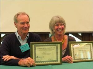
At the international conference of The International Ecotourism Society held in Nairobi on 25th to 27th September 2013, David Western and Megan Epler Wood were awarded Lifetime Achievement Awards for their contributions to ecotourism.
Western’s studies and planning efforts in wildlife tourism in Amboseli in the 1970s were cited as pioneering work leading to emergence of ecotourism.
Western and Megan Epler Wood jointly established The International Ecotourism Society in 1990 and Western and Chris Gakahu Ecotourism Kenya, the first ecotourism body in Africa five years later.
At the Nairobi conference Western looked at the progress in ecotourism since 1997 when TIES, the Kenya Wildlife Service and Ecotourism Kenya jointly hosted an international workshop on Ecotourism at a Crossroad.
He pointed out that Kenya at that time represented the worst and best of tourism. On one hand Kenya had become notorious for minibus tourism crowding lions and cheetahs in national parks, on the other as a pioneer in community-based ecotourism.
That same year Kenya Wildlife Service launched its Parks Beyond Parks movement to spur community conservation efforts on the 50th anniversary of park. The first community conservancy in Kenya was launched in Kenya the same year.
A decade and a half later, the movement has spawned over 150 conservancies covering more than 6 percent of the land area of Kenya and conserving more than all national parks and reserves combined. Dixon Kaiyelo of the Wildlife Conservancy Association of Kenya, John Kamanga, coordinator of the South Rift Association of Kenya, Daniel Letoiye of the Northern Rangelands Trust and Benson Laitayan of the Amboseli Ecosystsem Trust reviewed the remarkable growth of the Parks Beyond Parks movement and the growth of ecotourism from a community perspective.
http://www.responsibletravel.org/resources/documents/reports/TPhil_Conference_Kenya.pdf
Drought
Drought
ACP has studied the frequency and impact of drought in Amboseli over the past 47 years. Western began writing about the deepening threat of drought in the national press in 2000, in what he dubbed the millennial drought.
By then wildlife and livestock numbers in Amboseli and across Kenya were in decline due to shrinking range and degrading pastures, leading to a large scale collapse populations in 2009. The Worst Drought published in Swara detailed the collapse in Amboseli.
http://www.amboseliconservation.org/storage/Amboseli%20Drought%202009%20Swara.pdf .
A further article in Scidev.net based on the long-term studies of ACP in Amboseli looked at the wider implications in the Horn of Africa. http://www.scidev.net/global/desert-science/opinion/better-grazing-practices-hold-key-to-kenyan-droughts.html.
ACP has continued to track the aftermath of the drought in Amboseli (here refer to last update). The NASA Goddard Centre in Washington DC expressed interest in collaborating with ACP to calibrate satellite imagery against the Amboseli monitoring data through the drought period.
The preliminary finding show the prospects of coupling high tech satellite imagery with the low tech ground measurements of pasture and grazing David Maitumo conducts in Amboseli each month
http://www.earthzine.org/2013/07/22/tracking-vegetation-changes-in-kenyas-amboseli-national-park/
Victor Mose awarded a Ph.D. from Université Pierre et Marie Curie (UPMC), Paris VI.
Victor Mose awarded a Ph.D. from Université Pierre et Marie Curie (UPMC), Paris VI.
Victor Mose, ACP’s Head of Computation and Bio-statistical Services, successfully defended his Ph.D. titled
“Mathematical Modelling of the Dynamics of Migrations for Large Mammal Populations in the Amboseli National Park, Kenya”.
His work proposed a spatially explicit mathematical model of ungulate migrations based on the seasonal distribution of vegetation quantity, quality and allometric models of diet.
He studied the impact of blocked corridors on herbivore populations using a spatial mathematical model that describes the movements and population dynamics of selected species.
Aggregation methods were used to reduce the complexity of the model which uses actual parameters calibrated from long term data collected in Amboseli for over three decades.
The results show that a possible mechanism of maintenance of biodiversity in the area could be due to an exchange of animals between the park and surrounding ecosystems, when the oscillations of species densities in the ecosystems are out of phase compared to each other and to those within the park.
The migrants also broadly track the shifting patterns of vegetation growth and senescence according to body size.
http://www.sciencedirect.com/science/article/pii/S1476945X12000220
Do elephants get stressed living with people?
Do elephants get stressed living with people?

Quick Study is just what it says — a rapid-fire look at a new conservation science study that might turn some heads.
MAY 21, 2013 | by: DarciPalmquist |
The Study: Ahlering, M.A., J.E. Maldonado, L.S. Eggert, R.C. Fleischer, D. Western and J. Brown. 2013. Conservation outside protected areas and the effect of human-dominated landscapes on stress hormones in savannah elephants. Conservation Biology, 27: 569–575.
The Big Question: In East Africa, savannah elephants are increasingly expanding outside of protected parks and into surrounding areas where people and agriculture dominate.
Do elephants experience stress when living alongside human populations — even in situations where they are not being actively poached?
The answer, according to this new paper from lead author Marissa Ahlering of The Nature Conservancy and colleagues, can be found… in their poop.
Study Nuts and Bolts: The ability to measure stress hormones in wild animals has improved dramatically in the past decade with the development of fecal metabolite analysis techniques. In this study, scientists compared the levels of glucocorticoid (GC) hormone (which increases in response to stress) of elephants in a community conservation area (CCA) established by Maasai pastoralists with elephants at two nearby protected areas, Kenya’s Amboseli and Maasai Mara National Parks.
The elephants in the CCA are exposed to “dense human settlements, agricultural areas, and intense livestock grazing on a daily basis,” while the elephants in the national parks are exposed to humans to a lesser extent, only through ecotourism and research.
To measure the stress hormone, scientists collected fresh dung samples from which they extracted DNA and hormone samples. The hormone samples were frozen immediately in liquid nitrogen, transferred to Nairobi for storage and then shipped overnight on dry ice to the United States where they were run through a series of metabolic analyses.
The Findings: The researchers found no evidence of chronic stress in the elephants living within the CCA. The stress levels of the CCA elephants were the same as elephants in the nearby protected area of Maasai Mara, although elephants at Amboseli exhibited lower stress than the other two groups.
What it all Means: The results surprised the researchers — they expected the elephants in the CCA to exhibit higher levels of stress due to a higher degree of contact with humans. These findings indicate that elephants can successfully live in human-dominated areas — and suggest that CCAs should be part of the solution in efforts to restore elephants to areas where illegal ivory poaching has decimated their populations.
Ecosystem News
22
